You are here: Home > Network List > NN - Western Great Basin/Eastern Sierra Nevada Stations List
> Station WAK Walker, California w84 > Earthquake Result Viewer
WAK Walker, California w84 - Earthquake Result Viewer
| Earthquake location: |
Solomon Islands |
| Earthquake latitude/longitude: |
-11.3/162.2 |
| Earthquake time(UTC): |
2014/04/12 (102) 20:14:39 GMT |
| Earthquake Depth: |
29 km |
| Earthquake Magnitude: |
7.6 MWW, 8.3 MI |
| Earthquake Catalog/Contributor: |
NEIC PDE/NEIC COMCAT |
|
| Network: |
NN Western Great Basin/Eastern Sierra Nevada |
| Station: |
WAK Walker, California w84 |
| Lat/Lon: |
38.50 N/119.44 W |
| Elevation: |
1890 m |
|
| Distance: |
88.0 deg |
| Az: |
50.254 deg |
| Baz: |
253.984 deg |
| Ray Param: |
0.042860884 |
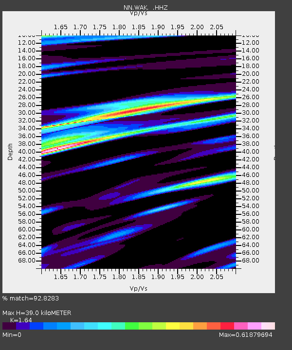
| Estimated Moho Depth: |
39.0 km |
| Estimated Crust Vp/Vs: |
1.64 |
| Assumed Crust Vp: |
6.279 km/s |
| Estimated Crust Vs: |
3.828 km/s |
| Estimated Crust Poisson's Ratio: |
0.20 |
|
| Radial Match: |
92.8283 % |
| Radial Bump: |
400 |
| Transverse Match: |
88.093544 % |
| Transverse Bump: |
400 |
| SOD ConfigId: |
626651 |
| Insert Time: |
2014-04-26 20:46:23.142 +0000 |
| GWidth: |
2.5 |
| Max Bumps: |
400 |
| Tol: |
0.001 |
|

Signal To Noise
| Channel | StoN | STA | LTA |
| NN:WAK: :HHZ:20140412T20:26:55.645024Z | 8.443568 | 1.2504759E-6 | 1.4809802E-7 |
| NN:WAK: :HHN:20140412T20:26:55.645024Z | 0.91251934 | 1.2702533E-7 | 1.392029E-7 |
| NN:WAK: :HHE:20140412T20:26:55.645024Z | 4.0652385 | 4.9705324E-7 | 1.2226914E-7 |
| Arrivals |
| Ps | 4.1 SECOND |
| PpPs | 16 SECOND |
| PsPs/PpSs | 20 SECOND |


