You are here: Home > Network List > RM - Regional Integrated Multi Hazard Early Warning System Stations List
> Station SLV Son La Vietnam > Earthquake Result Viewer
SLV Son La Vietnam - Earthquake Result Viewer
| Earthquake location: |
Solomon Islands |
| Earthquake latitude/longitude: |
-11.3/162.2 |
| Earthquake time(UTC): |
2014/04/12 (102) 20:14:39 GMT |
| Earthquake Depth: |
29 km |
| Earthquake Magnitude: |
7.6 MWW, 8.3 MI |
| Earthquake Catalog/Contributor: |
NEIC PDE/NEIC COMCAT |
|
| Network: |
RM Regional Integrated Multi Hazard Early Warning System |
| Station: |
SLV Son La Vietnam |
| Lat/Lon: |
21.33 N/103.91 E |
| Elevation: |
630 m |
|
| Distance: |
65.8 deg |
| Az: |
299.57 deg |
| Baz: |
113.8 deg |
| Ray Param: |
0.057992898 |
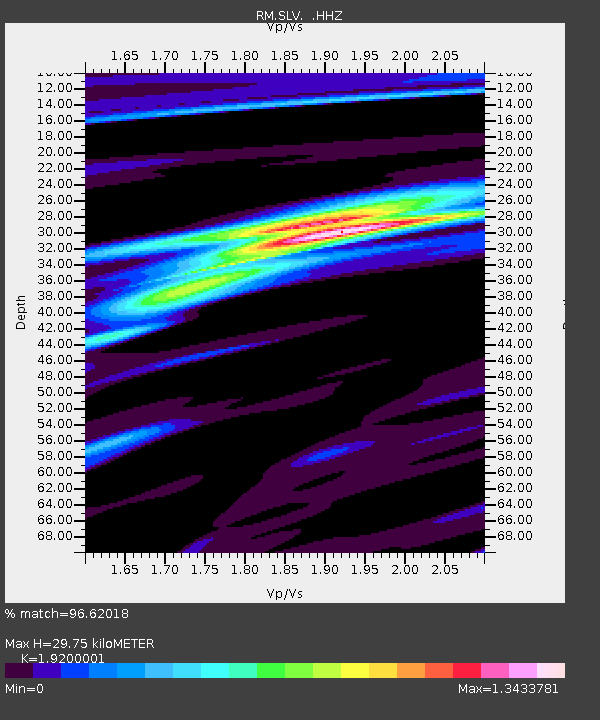
| Estimated Moho Depth: |
29.75 km |
| Estimated Crust Vp/Vs: |
1.92 |
| Assumed Crust Vp: |
6.35 km/s |
| Estimated Crust Vs: |
3.307 km/s |
| Estimated Crust Poisson's Ratio: |
0.31 |
|
| Radial Match: |
96.62018 % |
| Radial Bump: |
372 |
| Transverse Match: |
73.83506 % |
| Transverse Bump: |
400 |
| SOD ConfigId: |
626651 |
| Insert Time: |
2014-04-26 20:47:45.335 +0000 |
| GWidth: |
2.5 |
| Max Bumps: |
400 |
| Tol: |
0.001 |
|

Signal To Noise
| Channel | StoN | STA | LTA |
| RM:SLV: :HHZ:20140412T20:24:51.047979Z | 26.718622 | 4.1328285E-6 | 1.5467971E-7 |
| RM:SLV: :HHN:20140412T20:24:51.047979Z | 12.533344 | 5.0552717E-7 | 4.033458E-8 |
| RM:SLV: :HHE:20140412T20:24:51.047979Z | 13.889671 | 1.5249555E-6 | 1.0979061E-7 |
| Arrivals |
| Ps | 4.5 SECOND |
| PpPs | 13 SECOND |
| PsPs/PpSs | 18 SECOND |


