You are here: Home > Network List > TA - USArray Transportable Network (new EarthScope stations) Stations List
> Station D03D Eldon, WA, USA > Earthquake Result Viewer
D03D Eldon, WA, USA - Earthquake Result Viewer
| Earthquake location: |
Solomon Islands |
| Earthquake latitude/longitude: |
-11.3/162.2 |
| Earthquake time(UTC): |
2014/04/12 (102) 20:14:39 GMT |
| Earthquake Depth: |
29 km |
| Earthquake Magnitude: |
7.6 MWW, 8.3 MI |
| Earthquake Catalog/Contributor: |
NEIC PDE/NEIC COMCAT |
|
| Network: |
TA USArray Transportable Network (new EarthScope stations) |
| Station: |
D03D Eldon, WA, USA |
| Lat/Lon: |
47.53 N/123.09 W |
| Elevation: |
262 m |
|
| Distance: |
88.2 deg |
| Az: |
40.838 deg |
| Baz: |
251.18 deg |
| Ray Param: |
0.04275414 |
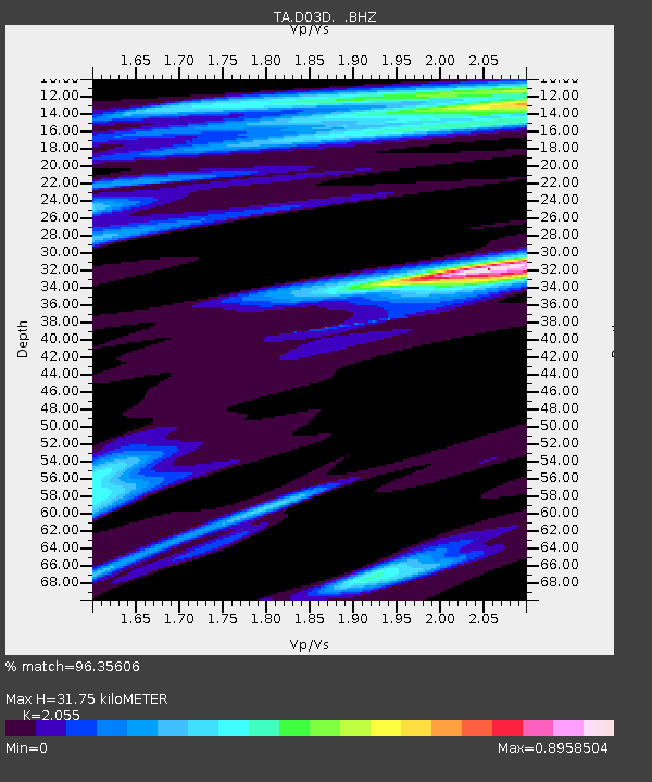
| Estimated Moho Depth: |
31.75 km |
| Estimated Crust Vp/Vs: |
2.06 |
| Assumed Crust Vp: |
6.566 km/s |
| Estimated Crust Vs: |
3.195 km/s |
| Estimated Crust Poisson's Ratio: |
0.34 |
|
| Radial Match: |
96.35606 % |
| Radial Bump: |
400 |
| Transverse Match: |
95.79834 % |
| Transverse Bump: |
383 |
| SOD ConfigId: |
626651 |
| Insert Time: |
2014-04-26 20:48:45.832 +0000 |
| GWidth: |
2.5 |
| Max Bumps: |
400 |
| Tol: |
0.001 |
|

Signal To Noise
| Channel | StoN | STA | LTA |
| TA:D03D: :BHZ:20140412T20:26:56.325017Z | 9.09414 | 1.5740316E-6 | 1.7308196E-7 |
| TA:D03D: :BHN:20140412T20:26:56.325017Z | 1.3544835 | 2.7577735E-7 | 2.0360332E-7 |
| TA:D03D: :BHE:20140412T20:26:56.325017Z | 2.8010802 | 3.6758357E-7 | 1.3122921E-7 |
| Arrivals |
| Ps | 5.2 SECOND |
| PpPs | 14 SECOND |
| PsPs/PpSs | 20 SECOND |


