You are here: Home > Network List > CI - Caltech Regional Seismic Network Stations List
> Station SWS Sam W. Stewart, Westmorland, CA, USA > Earthquake Result Viewer
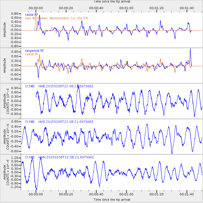
SWS Sam W. Stewart, Westmorland, CA, USA - Earthquake Result Viewer
*The percent match for this event was below the threshold and hence no stack was calculated.
| Earthquake location: |
Near Coast Of Nicaragua |
| Earthquake latitude/longitude: |
12.6/-87.8 |
| Earthquake time(UTC): |
2015/02/06 (037) 22:02:26 GMT |
| Earthquake Depth: |
75 km |
| Earthquake Magnitude: |
5.3 MW |
| Earthquake Catalog/Contributor: |
ISC/ISC |
|
| Network: |
CI Caltech Regional Seismic Network |
| Station: |
SWS Sam W. Stewart, Westmorland, CA, USA |
| Lat/Lon: |
32.94 N/115.80 W |
| Elevation: |
140 m |
|
| Distance: |
32.7 deg |
| Az: |
312.955 deg |
| Baz: |
121.815 deg |
| Ray Param: |
$rayparam |
*The percent match for this event was below the threshold and hence was not used in the summary stack. |
|
| Radial Match: |
69.6943 % |
| Radial Bump: |
361 |
| Transverse Match: |
55.342064 % |
| Transverse Bump: |
357 |
| SOD ConfigId: |
7019011 |
| Insert Time: |
2019-04-16 16:55:29.781 +0000 |
| GWidth: |
2.5 |
| Max Bumps: |
400 |
| Tol: |
0.001 |
|
Signal To Noise
| Channel | StoN | STA | LTA |
| CI:SWS: :HHZ:20150206T22:08:21.697996Z | 0.5634498 | 1.2722059E-7 | 2.257887E-7 |
| CI:SWS: :HHN:20150206T22:08:21.697996Z | 2.330974 | 8.8185334E-7 | 3.7831967E-7 |
| CI:SWS: :HHE:20150206T22:08:21.697996Z | 1.1884348 | 4.7864637E-7 | 4.0275356E-7 |
| Arrivals |
| Ps | |
| PpPs | |
| PsPs/PpSs | |


