You are here: Home > Network List > TA - USArray Transportable Network (new EarthScope stations) Stations List
> Station L04D Klamath Falls, OR, USA > Earthquake Result Viewer
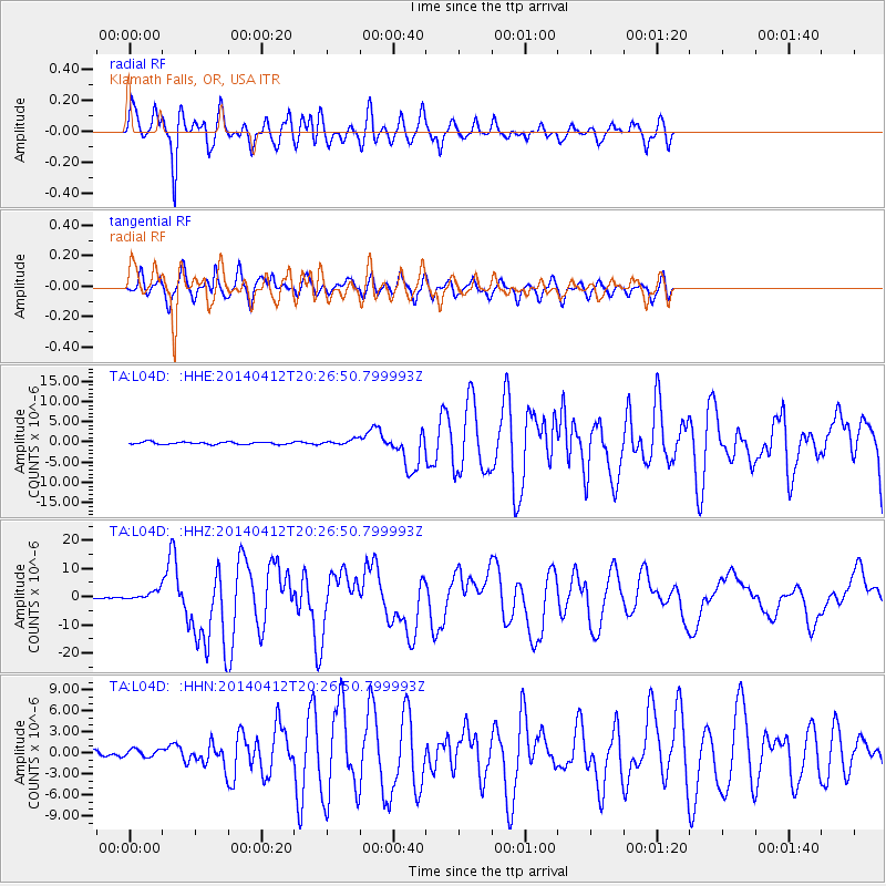
L04D Klamath Falls, OR, USA - Earthquake Result Viewer
*The percent match for this event was below the threshold and hence no stack was calculated.
| Earthquake location: |
Solomon Islands |
| Earthquake latitude/longitude: |
-11.3/162.2 |
| Earthquake time(UTC): |
2014/04/12 (102) 20:14:39 GMT |
| Earthquake Depth: |
29 km |
| Earthquake Magnitude: |
7.6 MWW, 8.3 MI |
| Earthquake Catalog/Contributor: |
NEIC PDE/NEIC COMCAT |
|
| Network: |
TA USArray Transportable Network (new EarthScope stations) |
| Station: |
L04D Klamath Falls, OR, USA |
| Lat/Lon: |
42.22 N/122.30 W |
| Elevation: |
1437 m |
|
| Distance: |
87.0 deg |
| Az: |
46.063 deg |
| Baz: |
251.952 deg |
| Ray Param: |
$rayparam |
*The percent match for this event was below the threshold and hence was not used in the summary stack. |
|
| Radial Match: |
85.37471 % |
| Radial Bump: |
400 |
| Transverse Match: |
81.63801 % |
| Transverse Bump: |
400 |
| SOD ConfigId: |
626651 |
| Insert Time: |
2014-04-26 20:49:30.848 +0000 |
| GWidth: |
2.5 |
| Max Bumps: |
400 |
| Tol: |
0.001 |
|
Signal To Noise
| Channel | StoN | STA | LTA |
| TA:L04D: :HHZ:20140412T20:26:50.799993Z | 7.266051 | 1.7042486E-6 | 2.345495E-7 |
| TA:L04D: :HHN:20140412T20:26:50.799993Z | 1.845368 | 5.562886E-7 | 3.0145134E-7 |
| TA:L04D: :HHE:20140412T20:26:50.799993Z | 2.2009435 | 6.515772E-7 | 2.9604448E-7 |
| Arrivals |
| Ps | |
| PpPs | |
| PsPs/PpSs | |


