You are here: Home > Network List > TA - USArray Transportable Network (new EarthScope stations) Stations List
> Station M04C Macdoel, CA, USA > Earthquake Result Viewer
M04C Macdoel, CA, USA - Earthquake Result Viewer
| Earthquake location: |
Solomon Islands |
| Earthquake latitude/longitude: |
-11.3/162.2 |
| Earthquake time(UTC): |
2014/04/12 (102) 20:14:39 GMT |
| Earthquake Depth: |
29 km |
| Earthquake Magnitude: |
7.6 MWW, 8.3 MI |
| Earthquake Catalog/Contributor: |
NEIC PDE/NEIC COMCAT |
|
| Network: |
TA USArray Transportable Network (new EarthScope stations) |
| Station: |
M04C Macdoel, CA, USA |
| Lat/Lon: |
41.78 N/121.84 W |
| Elevation: |
1391 m |
|
| Distance: |
87.2 deg |
| Az: |
46.584 deg |
| Baz: |
252.289 deg |
| Ray Param: |
0.043452494 |
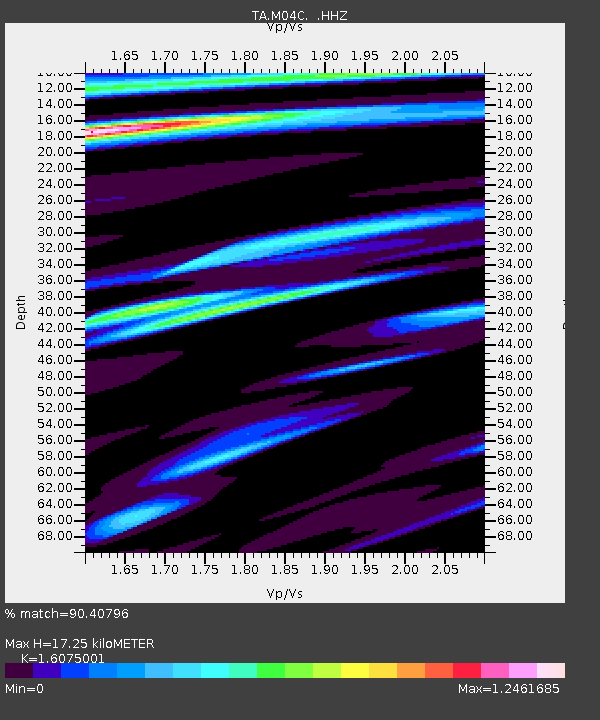
| Estimated Moho Depth: |
17.25 km |
| Estimated Crust Vp/Vs: |
1.61 |
| Assumed Crust Vp: |
6.566 km/s |
| Estimated Crust Vs: |
4.085 km/s |
| Estimated Crust Poisson's Ratio: |
0.18 |
|
| Radial Match: |
90.40796 % |
| Radial Bump: |
294 |
| Transverse Match: |
85.879875 % |
| Transverse Bump: |
400 |
| SOD ConfigId: |
626651 |
| Insert Time: |
2014-04-26 20:49:35.056 +0000 |
| GWidth: |
2.5 |
| Max Bumps: |
400 |
| Tol: |
0.001 |
|
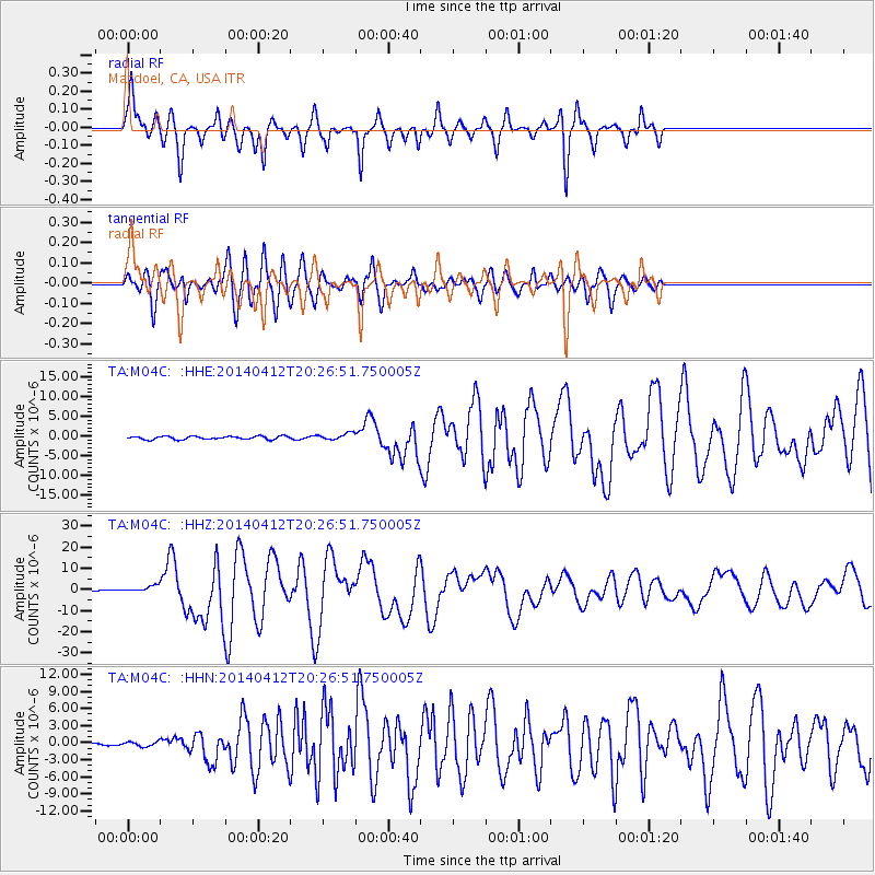
Signal To Noise
| Channel | StoN | STA | LTA |
| TA:M04C: :HHZ:20140412T20:26:51.750005Z | 8.11375 | 1.5708708E-6 | 1.9360601E-7 |
| TA:M04C: :HHN:20140412T20:26:51.750005Z | 1.1893958 | 4.1256632E-7 | 3.468705E-7 |
| TA:M04C: :HHE:20140412T20:26:51.750005Z | 2.1651177 | 8.5776884E-7 | 3.9617652E-7 |
| Arrivals |
| Ps | 1.6 SECOND |
| PpPs | 6.7 SECOND |
| PsPs/PpSs | 8.3 SECOND |


