You are here: Home > Network List > TA - USArray Transportable Network (new EarthScope stations) Stations List
> Station E64A Bridgewater, ME, USA > Earthquake Result Viewer
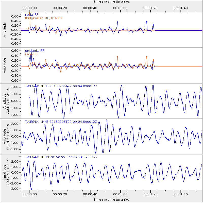
E64A Bridgewater, ME, USA - Earthquake Result Viewer
*The percent match for this event was below the threshold and hence no stack was calculated.
| Earthquake location: |
Near Coast Of Nicaragua |
| Earthquake latitude/longitude: |
12.6/-87.8 |
| Earthquake time(UTC): |
2015/02/06 (037) 22:02:26 GMT |
| Earthquake Depth: |
75 km |
| Earthquake Magnitude: |
5.3 MW |
| Earthquake Catalog/Contributor: |
ISC/ISC |
|
| Network: |
TA USArray Transportable Network (new EarthScope stations) |
| Station: |
E64A Bridgewater, ME, USA |
| Lat/Lon: |
46.42 N/67.83 W |
| Elevation: |
190 m |
|
| Distance: |
37.7 deg |
| Az: |
22.704 deg |
| Baz: |
213.003 deg |
| Ray Param: |
$rayparam |
*The percent match for this event was below the threshold and hence was not used in the summary stack. |
|
| Radial Match: |
75.01284 % |
| Radial Bump: |
400 |
| Transverse Match: |
75.21125 % |
| Transverse Bump: |
400 |
| SOD ConfigId: |
7019011 |
| Insert Time: |
2019-04-16 16:58:15.049 +0000 |
| GWidth: |
2.5 |
| Max Bumps: |
400 |
| Tol: |
0.001 |
|
Signal To Noise
| Channel | StoN | STA | LTA |
| TA:E64A: :HHZ:20150206T22:09:04.890012Z | 0.20923397 | 4.4915822E-7 | 2.1466792E-6 |
| TA:E64A: :HHN:20150206T22:09:04.890012Z | 2.4692976 | 1.772271E-6 | 7.177227E-7 |
| TA:E64A: :HHE:20150206T22:09:04.890012Z | 0.36011672 | 4.6591563E-7 | 1.2937907E-6 |
| Arrivals |
| Ps | |
| PpPs | |
| PsPs/PpSs | |


