You are here: Home > Network List > US - United States National Seismic Network Stations List
> Station MSO Missoula, Montana, USA > Earthquake Result Viewer
MSO Missoula, Montana, USA - Earthquake Result Viewer
| Earthquake location: |
Solomon Islands |
| Earthquake latitude/longitude: |
-11.3/162.2 |
| Earthquake time(UTC): |
2014/04/12 (102) 20:14:39 GMT |
| Earthquake Depth: |
29 km |
| Earthquake Magnitude: |
7.6 MWW, 8.3 MI |
| Earthquake Catalog/Contributor: |
NEIC PDE/NEIC COMCAT |
|
| Network: |
US United States National Seismic Network |
| Station: |
MSO Missoula, Montana, USA |
| Lat/Lon: |
46.83 N/113.94 W |
| Elevation: |
1264 m |
|
| Distance: |
94.0 deg |
| Az: |
43.182 deg |
| Baz: |
257.832 deg |
| Ray Param: |
0.04113768 |
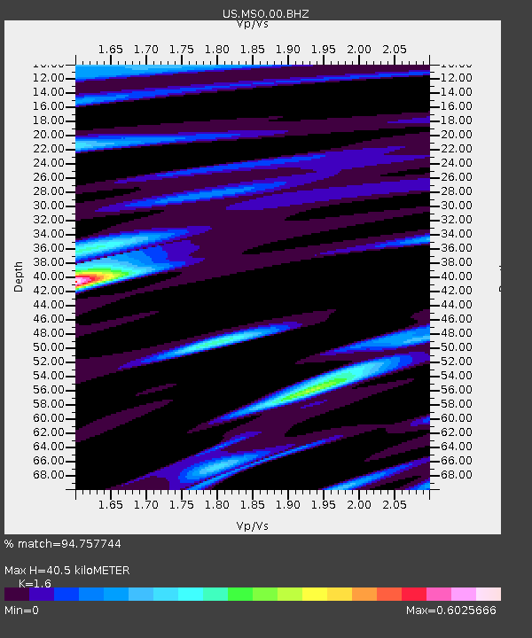
| Estimated Moho Depth: |
40.5 km |
| Estimated Crust Vp/Vs: |
1.60 |
| Assumed Crust Vp: |
6.353 km/s |
| Estimated Crust Vs: |
3.971 km/s |
| Estimated Crust Poisson's Ratio: |
0.18 |
|
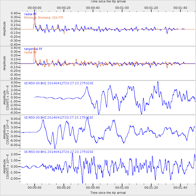
| Radial Match: |
94.757744 % |
| Radial Bump: |
400 |
| Transverse Match: |
80.7625 % |
| Transverse Bump: |
400 |
| SOD ConfigId: |
626651 |
| Insert Time: |
2014-04-26 20:50:40.653 +0000 |
| GWidth: |
2.5 |
| Max Bumps: |
400 |
| Tol: |
0.001 |
|
Signal To Noise
| Channel | StoN | STA | LTA |
| US:MSO:00:BHZ:20140412T20:27:23.275029Z | 21.447927 | 1.6507304E-6 | 7.696457E-8 |
| US:MSO:00:BH1:20140412T20:27:23.275029Z | 0.80384797 | 1.1683358E-7 | 1.453429E-7 |
| US:MSO:00:BH2:20140412T20:27:23.275029Z | 2.9858243 | 5.614348E-7 | 1.8803343E-7 |
| Arrivals |
| Ps | 3.9 SECOND |
| PpPs | 16 SECOND |
| PsPs/PpSs | 20 SECOND |


