You are here: Home > Network List > US - United States National Seismic Network Stations List
> Station NLWA Neilton Lookout, Washington, USA > Earthquake Result Viewer
NLWA Neilton Lookout, Washington, USA - Earthquake Result Viewer
| Earthquake location: |
Solomon Islands |
| Earthquake latitude/longitude: |
-11.3/162.2 |
| Earthquake time(UTC): |
2014/04/12 (102) 20:14:39 GMT |
| Earthquake Depth: |
29 km |
| Earthquake Magnitude: |
7.6 MWW, 8.3 MI |
| Earthquake Catalog/Contributor: |
NEIC PDE/NEIC COMCAT |
|
| Network: |
US United States National Seismic Network |
| Station: |
NLWA Neilton Lookout, Washington, USA |
| Lat/Lon: |
47.39 N/123.87 W |
| Elevation: |
640 m |
|
| Distance: |
87.6 deg |
| Az: |
40.8 deg |
| Baz: |
250.605 deg |
| Ray Param: |
0.043160196 |
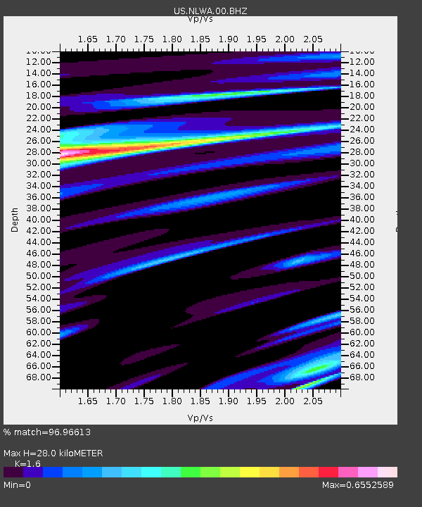
| Estimated Moho Depth: |
28.0 km |
| Estimated Crust Vp/Vs: |
1.60 |
| Assumed Crust Vp: |
6.566 km/s |
| Estimated Crust Vs: |
4.104 km/s |
| Estimated Crust Poisson's Ratio: |
0.18 |
|
| Radial Match: |
96.96613 % |
| Radial Bump: |
400 |
| Transverse Match: |
92.82874 % |
| Transverse Bump: |
400 |
| SOD ConfigId: |
626651 |
| Insert Time: |
2014-04-26 20:50:45.952 +0000 |
| GWidth: |
2.5 |
| Max Bumps: |
400 |
| Tol: |
0.001 |
|

Signal To Noise
| Channel | StoN | STA | LTA |
| US:NLWA:00:BHZ:20140412T20:26:53.724004Z | 7.592857 | 1.8280671E-6 | 2.4076144E-7 |
| US:NLWA:00:BH1:20140412T20:26:53.724004Z | 1.2879741 | 2.9331818E-7 | 2.2773607E-7 |
| US:NLWA:00:BH2:20140412T20:26:53.724004Z | 2.6508238 | 6.367955E-7 | 2.4022552E-7 |
| Arrivals |
| Ps | 2.6 SECOND |
| PpPs | 11 SECOND |
| PsPs/PpSs | 13 SECOND |


