You are here: Home > Network List > US - United States National Seismic Network Stations List
> Station TPNV Topopah Spring, Nevada, USA > Earthquake Result Viewer
TPNV Topopah Spring, Nevada, USA - Earthquake Result Viewer
| Earthquake location: |
Solomon Islands |
| Earthquake latitude/longitude: |
-11.3/162.2 |
| Earthquake time(UTC): |
2014/04/12 (102) 20:14:39 GMT |
| Earthquake Depth: |
29 km |
| Earthquake Magnitude: |
7.6 MWW, 8.3 MI |
| Earthquake Catalog/Contributor: |
NEIC PDE/NEIC COMCAT |
|
| Network: |
US United States National Seismic Network |
| Station: |
TPNV Topopah Spring, Nevada, USA |
| Lat/Lon: |
36.95 N/116.25 W |
| Elevation: |
1600 m |
|
| Distance: |
90.1 deg |
| Az: |
52.409 deg |
| Baz: |
255.964 deg |
| Ray Param: |
0.04169696 |
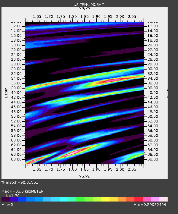
| Estimated Moho Depth: |
65.5 km |
| Estimated Crust Vp/Vs: |
1.79 |
| Assumed Crust Vp: |
6.279 km/s |
| Estimated Crust Vs: |
3.508 km/s |
| Estimated Crust Poisson's Ratio: |
0.27 |
|
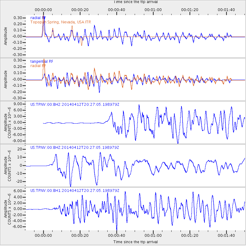
| Radial Match: |
90.61551 % |
| Radial Bump: |
400 |
| Transverse Match: |
86.42816 % |
| Transverse Bump: |
400 |
| SOD ConfigId: |
626651 |
| Insert Time: |
2014-04-26 20:50:50.716 +0000 |
| GWidth: |
2.5 |
| Max Bumps: |
400 |
| Tol: |
0.001 |
|
Signal To Noise
| Channel | StoN | STA | LTA |
| US:TPNV:00:BHZ:20140412T20:27:05.198979Z | 9.753062 | 9.750509E-7 | 9.997381E-8 |
| US:TPNV:00:BH1:20140412T20:27:05.198979Z | 1.2880135 | 1.9927676E-7 | 1.5471636E-7 |
| US:TPNV:00:BH2:20140412T20:27:05.198979Z | 2.4291017 | 3.44314E-7 | 1.417454E-7 |
| Arrivals |
| Ps | 8.4 SECOND |
| PpPs | 29 SECOND |
| PsPs/PpSs | 37 SECOND |


