You are here: Home > Network List > TA - USArray Transportable Network (new EarthScope stations) Stations List
> Station I23K Minto, Yukon-Koyukuk, AK, USA > Earthquake Result Viewer
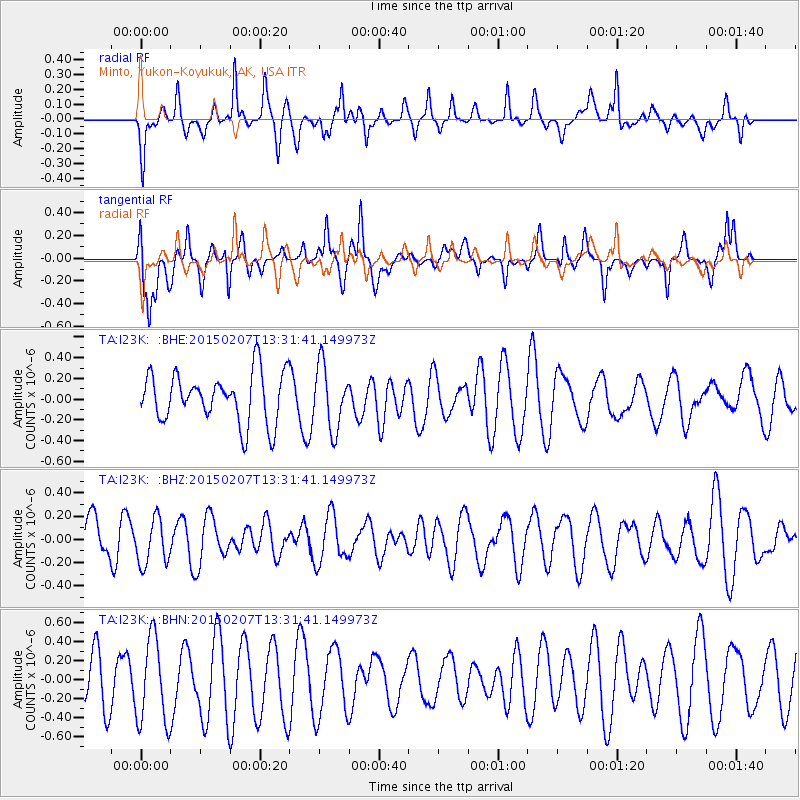
I23K Minto, Yukon-Koyukuk, AK, USA - Earthquake Result Viewer
*The percent match for this event was below the threshold and hence no stack was calculated.
| Earthquake location: |
Halmahera, Indonesia |
| Earthquake latitude/longitude: |
2.0/127.3 |
| Earthquake time(UTC): |
2015/02/07 (038) 13:19:47 GMT |
| Earthquake Depth: |
112 km |
| Earthquake Magnitude: |
4.7 mb |
| Earthquake Catalog/Contributor: |
ISC/ISC |
|
| Network: |
TA USArray Transportable Network (new EarthScope stations) |
| Station: |
I23K Minto, Yukon-Koyukuk, AK, USA |
| Lat/Lon: |
65.15 N/149.36 W |
| Elevation: |
149 m |
|
| Distance: |
85.4 deg |
| Az: |
24.904 deg |
| Baz: |
264.773 deg |
| Ray Param: |
$rayparam |
*The percent match for this event was below the threshold and hence was not used in the summary stack. |
|
| Radial Match: |
50.265545 % |
| Radial Bump: |
298 |
| Transverse Match: |
49.700493 % |
| Transverse Bump: |
383 |
| SOD ConfigId: |
7019011 |
| Insert Time: |
2019-04-16 17:03:09.674 +0000 |
| GWidth: |
2.5 |
| Max Bumps: |
400 |
| Tol: |
0.001 |
|
Signal To Noise
| Channel | StoN | STA | LTA |
| TA:I23K: :BHZ:20150207T13:31:41.149973Z | 1.2974102 | 1.9936759E-7 | 1.5366581E-7 |
| TA:I23K: :BHN:20150207T13:31:41.149973Z | 2.4520316 | 4.5101004E-7 | 1.839332E-7 |
| TA:I23K: :BHE:20150207T13:31:41.149973Z | 1.2819186 | 3.061036E-7 | 2.387855E-7 |
| Arrivals |
| Ps | |
| PpPs | |
| PsPs/PpSs | |


