You are here: Home > Network List > WY - Yellowstone Wyoming Seismic Network Stations List
> Station YHH Holmes Hill, YNP, WY, USA > Earthquake Result Viewer
YHH Holmes Hill, YNP, WY, USA - Earthquake Result Viewer
| Earthquake location: |
Solomon Islands |
| Earthquake latitude/longitude: |
-11.3/162.2 |
| Earthquake time(UTC): |
2014/04/12 (102) 20:14:39 GMT |
| Earthquake Depth: |
29 km |
| Earthquake Magnitude: |
7.6 MWW, 8.3 MI |
| Earthquake Catalog/Contributor: |
NEIC PDE/NEIC COMCAT |
|
| Network: |
WY Yellowstone Wyoming Seismic Network |
| Station: |
YHH Holmes Hill, YNP, WY, USA |
| Lat/Lon: |
44.79 N/110.85 W |
| Elevation: |
2717 m |
|
| Distance: |
95.7 deg |
| Az: |
45.611 deg |
| Baz: |
259.836 deg |
| Ray Param: |
0.040697105 |
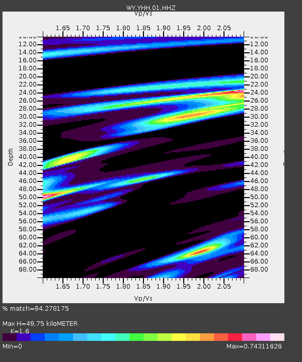
| Estimated Moho Depth: |
49.75 km |
| Estimated Crust Vp/Vs: |
1.60 |
| Assumed Crust Vp: |
6.35 km/s |
| Estimated Crust Vs: |
3.969 km/s |
| Estimated Crust Poisson's Ratio: |
0.18 |
|
| Radial Match: |
94.278175 % |
| Radial Bump: |
319 |
| Transverse Match: |
92.97484 % |
| Transverse Bump: |
400 |
| SOD ConfigId: |
626651 |
| Insert Time: |
2014-04-26 20:53:24.856 +0000 |
| GWidth: |
2.5 |
| Max Bumps: |
400 |
| Tol: |
0.001 |
|
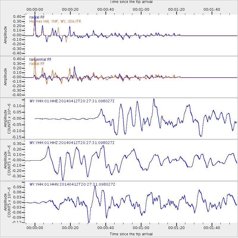
Signal To Noise
| Channel | StoN | STA | LTA |
| WY:YHH:01:HHZ:20140412T20:27:31.098027Z | 8.048351 | 1.3629392E-8 | 1.693439E-9 |
| WY:YHH:01:HHN:20140412T20:27:31.098027Z | 1.662876 | 3.2748568E-9 | 1.969393E-9 |
| WY:YHH:01:HHE:20140412T20:27:31.098027Z | 1.6948085 | 4.2001282E-9 | 2.4782316E-9 |
| Arrivals |
| Ps | 4.8 SECOND |
| PpPs | 20 SECOND |
| PsPs/PpSs | 25 SECOND |


