You are here: Home > Network List > BK - Berkeley Digital Seismograph Network Stations List
> Station HUMO Hull Mountain, OR > Earthquake Result Viewer
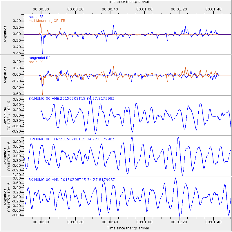
HUMO Hull Mountain, OR - Earthquake Result Viewer
*The percent match for this event was below the threshold and hence no stack was calculated.
| Earthquake location: |
South Of Kermadec Islands |
| Earthquake latitude/longitude: |
-34.3/179.3 |
| Earthquake time(UTC): |
2015/02/08 (039) 15:22:10 GMT |
| Earthquake Depth: |
218 km |
| Earthquake Magnitude: |
5.2 MW |
| Earthquake Catalog/Contributor: |
ISC/ISC |
|
| Network: |
BK Berkeley Digital Seismograph Network |
| Station: |
HUMO Hull Mountain, OR |
| Lat/Lon: |
42.61 N/122.96 W |
| Elevation: |
555 m |
|
| Distance: |
93.0 deg |
| Az: |
38.712 deg |
| Baz: |
224.509 deg |
| Ray Param: |
$rayparam |
*The percent match for this event was below the threshold and hence was not used in the summary stack. |
|
| Radial Match: |
75.317924 % |
| Radial Bump: |
400 |
| Transverse Match: |
58.587833 % |
| Transverse Bump: |
336 |
| SOD ConfigId: |
7019011 |
| Insert Time: |
2019-04-16 17:09:29.607 +0000 |
| GWidth: |
2.5 |
| Max Bumps: |
400 |
| Tol: |
0.001 |
|
Signal To Noise
| Channel | StoN | STA | LTA |
| BK:HUMO:00:HHZ:20150208T15:34:27.817998Z | 0.8695953 | 4.4795465E-7 | 5.1513E-7 |
| BK:HUMO:00:HHN:20150208T15:34:27.817998Z | 0.65021765 | 1.5664669E-7 | 2.4091426E-7 |
| BK:HUMO:00:HHE:20150208T15:34:27.817998Z | 1.922684 | 6.209367E-7 | 3.229531E-7 |
| Arrivals |
| Ps | |
| PpPs | |
| PsPs/PpSs | |


