You are here: Home > Network List > AK - Alaska Regional Network Stations List
> Station PWL Port Wells, AK, USA > Earthquake Result Viewer
PWL Port Wells, AK, USA - Earthquake Result Viewer
| Earthquake location: |
Solomon Islands |
| Earthquake latitude/longitude: |
-11.5/162.1 |
| Earthquake time(UTC): |
2014/04/13 (103) 12:36:18 GMT |
| Earthquake Depth: |
35 km |
| Earthquake Magnitude: |
7.4 MWW, 7.7 MI |
| Earthquake Catalog/Contributor: |
NEIC PDE/NEIC COMCAT |
|
| Network: |
AK Alaska Regional Network |
| Station: |
PWL Port Wells, AK, USA |
| Lat/Lon: |
60.86 N/148.33 W |
| Elevation: |
550 m |
|
| Distance: |
82.0 deg |
| Az: |
22.11 deg |
| Baz: |
228.926 deg |
| Ray Param: |
0.047136158 |
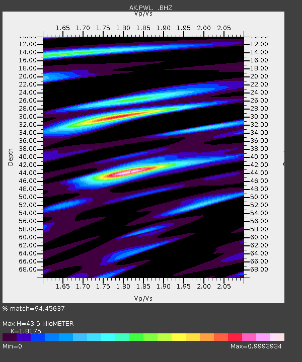
| Estimated Moho Depth: |
43.5 km |
| Estimated Crust Vp/Vs: |
1.82 |
| Assumed Crust Vp: |
6.566 km/s |
| Estimated Crust Vs: |
3.613 km/s |
| Estimated Crust Poisson's Ratio: |
0.28 |
|
| Radial Match: |
94.45637 % |
| Radial Bump: |
400 |
| Transverse Match: |
83.61986 % |
| Transverse Bump: |
400 |
| SOD ConfigId: |
626651 |
| Insert Time: |
2014-04-27 12:48:02.453 +0000 |
| GWidth: |
2.5 |
| Max Bumps: |
400 |
| Tol: |
0.001 |
|

Signal To Noise
| Channel | StoN | STA | LTA |
| AK:PWL: :BHZ:20140413T12:48:04.048013Z | 13.515054 | 5.748869E-6 | 4.2536786E-7 |
| AK:PWL: :BHN:20140413T12:48:04.048013Z | 5.1788564 | 1.5239781E-6 | 2.9426926E-7 |
| AK:PWL: :BHE:20140413T12:48:04.048013Z | 4.58931 | 1.7509652E-6 | 3.8153127E-7 |
| Arrivals |
| Ps | 5.6 SECOND |
| PpPs | 18 SECOND |
| PsPs/PpSs | 24 SECOND |


