You are here: Home > Network List > AU - Australian Seismological Centre Stations List
> Station PSAD2 Pilbara Seismic Array Element D2 > Earthquake Result Viewer
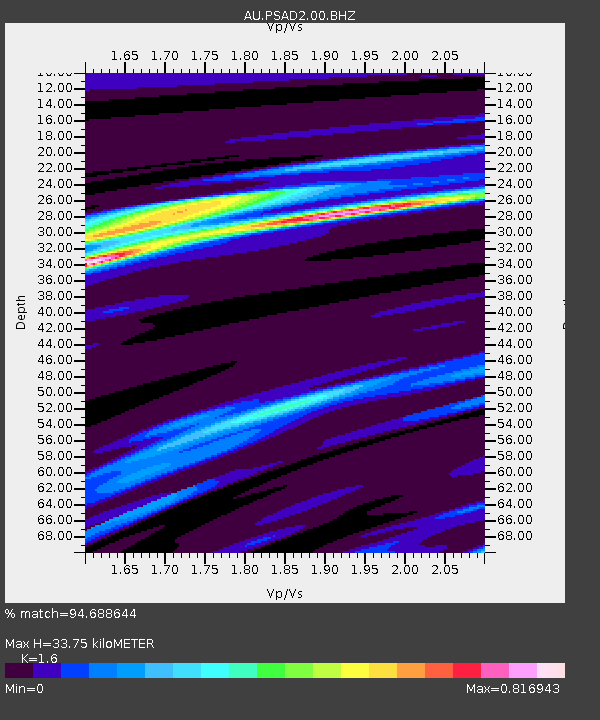
PSAD2 Pilbara Seismic Array Element D2 - Earthquake Result Viewer
| Earthquake location: |
Solomon Islands |
| Earthquake latitude/longitude: |
-11.5/162.1 |
| Earthquake time(UTC): |
2014/04/13 (103) 12:36:18 GMT |
| Earthquake Depth: |
35 km |
| Earthquake Magnitude: |
7.4 MWW, 7.7 MI |
| Earthquake Catalog/Contributor: |
NEIC PDE/NEIC COMCAT |
|
| Network: |
AU Australian Seismological Centre |
| Station: |
PSAD2 Pilbara Seismic Array Element D2 |
| Lat/Lon: |
21.62 S/119.96 E |
| Elevation: |
366 m |
|
| Distance: |
41.5 deg |
| Az: |
250.34 deg |
| Baz: |
82.817 deg |
| Ray Param: |
0.07368317 |
| Estimated Moho Depth: |
33.75 km |
| Estimated Crust Vp/Vs: |
1.60 |
| Assumed Crust Vp: |
6.464 km/s |
| Estimated Crust Vs: |
4.04 km/s |
| Estimated Crust Poisson's Ratio: |
0.18 |
|
| Radial Match: |
94.688644 % |
| Radial Bump: |
216 |
| Transverse Match: |
91.69839 % |
| Transverse Bump: |
371 |
| SOD ConfigId: |
626651 |
| Insert Time: |
2014-04-27 12:50:16.921 +0000 |
| GWidth: |
2.5 |
| Max Bumps: |
400 |
| Tol: |
0.001 |
|

Signal To Noise
| Channel | StoN | STA | LTA |
| AU:PSAD2:00:BHZ:20140413T12:43:31.969003Z | 87.61449 | 3.346631E-5 | 3.8197234E-7 |
| AU:PSAD2:00:BH1:20140413T12:43:31.969003Z | 103.64472 | 2.2633829E-5 | 2.1837899E-7 |
| AU:PSAD2:00:BH2:20140413T12:43:31.969003Z | 5.2479773 | 1.0104014E-6 | 1.925316E-7 |
| Arrivals |
| Ps | 3.4 SECOND |
| PpPs | 13 SECOND |
| PsPs/PpSs | 16 SECOND |


