You are here: Home > Network List > II - Global Seismograph Network (GSN - IRIS/IDA) Stations List
> Station KDAK Kodiak Island, Alaska, USA > Earthquake Result Viewer
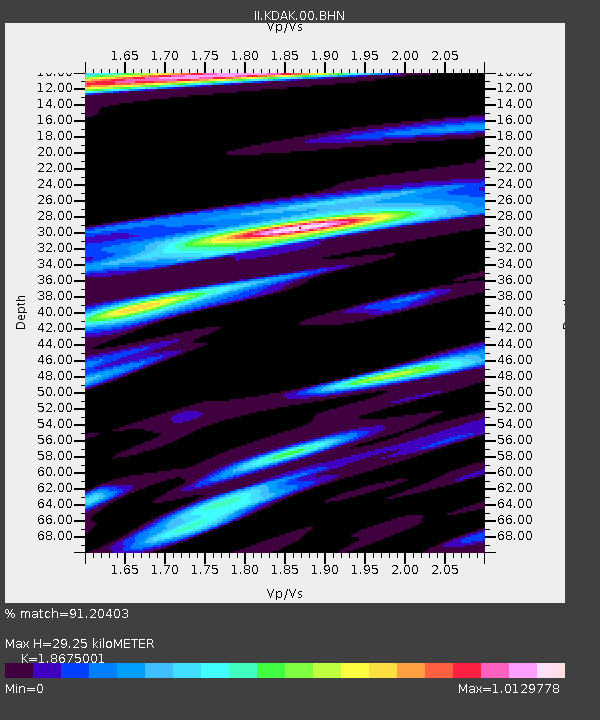
KDAK Kodiak Island, Alaska, USA - Earthquake Result Viewer
| Earthquake location: |
Fiji Islands Region |
| Earthquake latitude/longitude: |
-21.7/-176.7 |
| Earthquake time(UTC): |
2001/07/04 (185) 07:06:31 GMT |
| Earthquake Depth: |
185 km |
| Earthquake Magnitude: |
5.9 MB, 5.8 MS, 6.5 MW, 6.5 MW |
| Earthquake Catalog/Contributor: |
WHDF/NEIC |
|
| Network: |
II Global Seismograph Network (GSN - IRIS/IDA) |
| Station: |
KDAK Kodiak Island, Alaska, USA |
| Lat/Lon: |
57.78 N/152.58 W |
| Elevation: |
152 m |
|
| Distance: |
81.7 deg |
| Az: |
12.781 deg |
| Baz: |
202.581 deg |
| Ray Param: |
0.04693335 |
| Estimated Moho Depth: |
29.25 km |
| Estimated Crust Vp/Vs: |
1.87 |
| Assumed Crust Vp: |
6.134 km/s |
| Estimated Crust Vs: |
3.285 km/s |
| Estimated Crust Poisson's Ratio: |
0.30 |
|
| Radial Match: |
91.20403 % |
| Radial Bump: |
326 |
| Transverse Match: |
77.996704 % |
| Transverse Bump: |
400 |
| SOD ConfigId: |
4714 |
| Insert Time: |
2010-03-01 20:56:14.060 +0000 |
| GWidth: |
2.5 |
| Max Bumps: |
400 |
| Tol: |
0.001 |
|

Signal To Noise
| Channel | StoN | STA | LTA |
| II:KDAK:00:BHN:20010704T07:17:58.350Z | 5.281771 | 7.4715473E-7 | 1.4145913E-7 |
| II:KDAK:00:BHE:20010704T07:17:58.350Z | 2.8433206 | 5.07159E-7 | 1.7836855E-7 |
| II:KDAK:00:BHZ:20010704T07:17:58.350Z | 13.594924 | 2.1843016E-6 | 1.6067038E-7 |
| Arrivals |
| Ps | 4.2 SECOND |
| PpPs | 13 SECOND |
| PsPs/PpSs | 18 SECOND |


