You are here: Home > Network List > CN - Canadian National Seismograph Network Stations List
> Station VIB VAN INLET, BC > Earthquake Result Viewer
VIB VAN INLET, BC - Earthquake Result Viewer

| Earthquake location: |
Solomon Islands |
| Earthquake latitude/longitude: |
-11.5/162.1 |
| Earthquake time(UTC): |
2014/04/13 (103) 12:36:18 GMT |
| Earthquake Depth: |
35 km |
| Earthquake Magnitude: |
7.4 MWW, 7.7 MI |
| Earthquake Catalog/Contributor: |
NEIC PDE/NEIC COMCAT |
|
| Network: |
CN Canadian National Seismograph Network |
| Station: |
VIB VAN INLET, BC |
| Lat/Lon: |
53.25 N/132.54 W |
| Elevation: |
1008 m |
|
| Distance: |
85.0 deg |
| Az: |
33.258 deg |
| Baz: |
243.476 deg |
| Ray Param: |
0.045051437 |
| Estimated Moho Depth: |
29.5 km |
| Estimated Crust Vp/Vs: |
1.65 |
| Assumed Crust Vp: |
6.183 km/s |
| Estimated Crust Vs: |
3.741 km/s |
| Estimated Crust Poisson's Ratio: |
0.21 |
|
| Radial Match: |
95.18873 % |
| Radial Bump: |
400 |
| Transverse Match: |
87.09675 % |
| Transverse Bump: |
400 |
| SOD ConfigId: |
626651 |
| Insert Time: |
2014-04-27 12:54:21.109 +0000 |
| GWidth: |
2.5 |
| Max Bumps: |
400 |
| Tol: |
0.001 |
|
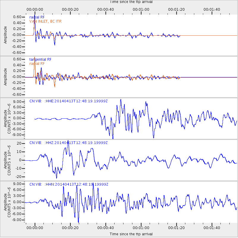
Signal To Noise
| Channel | StoN | STA | LTA |
| CN:VIB: :HHZ:20140413T12:48:19.19999Z | 23.663414 | 3.907749E-6 | 1.6513886E-7 |
| CN:VIB: :HHN:20140413T12:48:19.19999Z | 3.3442805 | 7.5187864E-7 | 2.2482524E-7 |
| CN:VIB: :HHE:20140413T12:48:19.19999Z | 5.8008227 | 1.3843616E-6 | 2.3864916E-7 |
| Arrivals |
| Ps | 3.2 SECOND |
| PpPs | 12 SECOND |
| PsPs/PpSs | 16 SECOND |


