You are here: Home > Network List > G - GEOSCOPE Stations List
> Station AIS New Amsterdam, Indian Ocean > Earthquake Result Viewer
AIS New Amsterdam, Indian Ocean - Earthquake Result Viewer
| Earthquake location: |
Solomon Islands |
| Earthquake latitude/longitude: |
-11.5/162.1 |
| Earthquake time(UTC): |
2014/04/13 (103) 12:36:18 GMT |
| Earthquake Depth: |
35 km |
| Earthquake Magnitude: |
7.4 MWW, 7.7 MI |
| Earthquake Catalog/Contributor: |
NEIC PDE/NEIC COMCAT |
|
| Network: |
G GEOSCOPE |
| Station: |
AIS New Amsterdam, Indian Ocean |
| Lat/Lon: |
37.80 S/77.57 E |
| Elevation: |
35 m |
|
| Distance: |
78.8 deg |
| Az: |
233.507 deg |
| Baz: |
95.788 deg |
| Ray Param: |
0.04936944 |
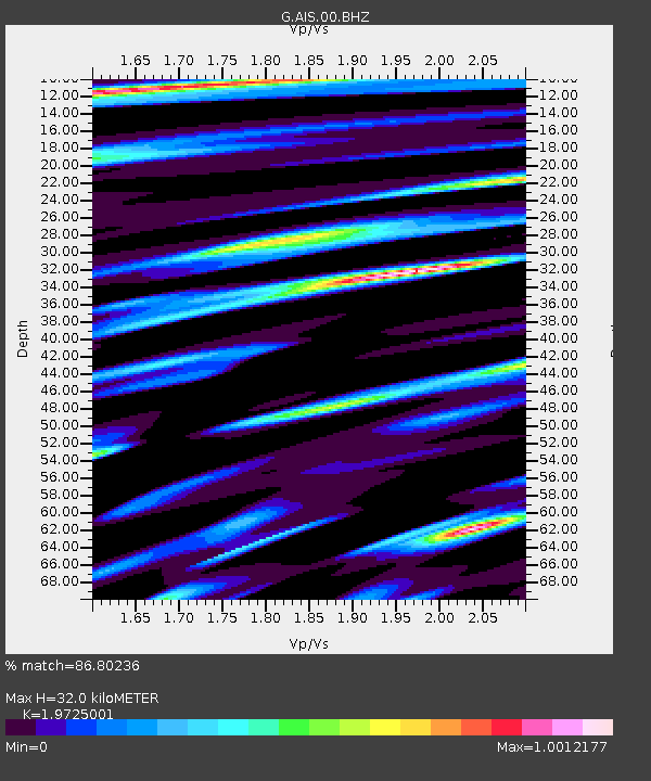
| Estimated Moho Depth: |
32.0 km |
| Estimated Crust Vp/Vs: |
1.97 |
| Assumed Crust Vp: |
4.802 km/s |
| Estimated Crust Vs: |
2.434 km/s |
| Estimated Crust Poisson's Ratio: |
0.33 |
|
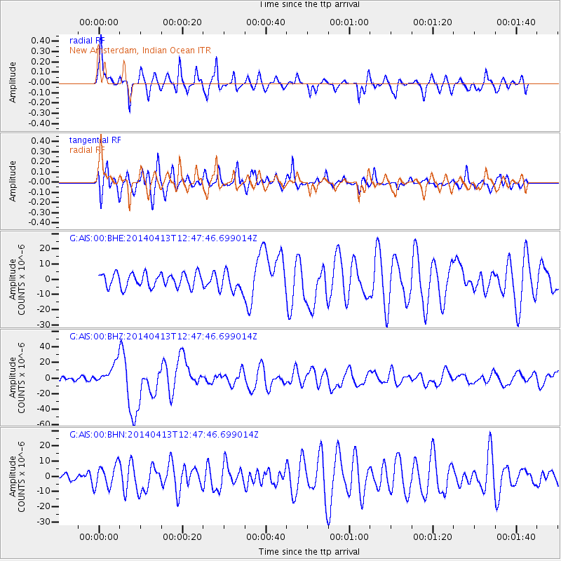
| Radial Match: |
86.80236 % |
| Radial Bump: |
399 |
| Transverse Match: |
76.21777 % |
| Transverse Bump: |
400 |
| SOD ConfigId: |
626651 |
| Insert Time: |
2014-04-27 12:54:35.730 +0000 |
| GWidth: |
2.5 |
| Max Bumps: |
400 |
| Tol: |
0.001 |
|
Signal To Noise
| Channel | StoN | STA | LTA |
| G:AIS:00:BHZ:20140413T12:47:46.699014Z | 3.6957822 | 1.4397969E-5 | 3.8957837E-6 |
| G:AIS:00:BHN:20140413T12:47:46.699014Z | 1.8562169 | 7.2499442E-6 | 3.905763E-6 |
| G:AIS:00:BHE:20140413T12:47:46.699014Z | 1.5071461 | 6.7553724E-6 | 4.4822277E-6 |
| Arrivals |
| Ps | 6.6 SECOND |
| PpPs | 20 SECOND |
| PsPs/PpSs | 26 SECOND |


