You are here: Home > Network List > G - GEOSCOPE Stations List
> Station CRZF Port Alfred, Crozet, South Indian Ocean > Earthquake Result Viewer
CRZF Port Alfred, Crozet, South Indian Ocean - Earthquake Result Viewer
| Earthquake location: |
Solomon Islands |
| Earthquake latitude/longitude: |
-11.5/162.1 |
| Earthquake time(UTC): |
2014/04/13 (103) 12:36:18 GMT |
| Earthquake Depth: |
35 km |
| Earthquake Magnitude: |
7.4 MWW, 7.7 MI |
| Earthquake Catalog/Contributor: |
NEIC PDE/NEIC COMCAT |
|
| Network: |
G GEOSCOPE |
| Station: |
CRZF Port Alfred, Crozet, South Indian Ocean |
| Lat/Lon: |
46.43 S/51.86 E |
| Elevation: |
140 m |
|
| Distance: |
95.3 deg |
| Az: |
220.681 deg |
| Baz: |
112.496 deg |
| Ray Param: |
0.04081236 |
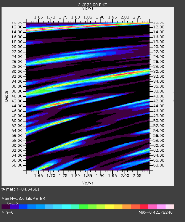
| Estimated Moho Depth: |
13.0 km |
| Estimated Crust Vp/Vs: |
1.60 |
| Assumed Crust Vp: |
4.802 km/s |
| Estimated Crust Vs: |
3.001 km/s |
| Estimated Crust Poisson's Ratio: |
0.18 |
|
| Radial Match: |
84.64681 % |
| Radial Bump: |
376 |
| Transverse Match: |
66.069275 % |
| Transverse Bump: |
400 |
| SOD ConfigId: |
626651 |
| Insert Time: |
2014-04-27 12:54:37.469 +0000 |
| GWidth: |
2.5 |
| Max Bumps: |
400 |
| Tol: |
0.001 |
|
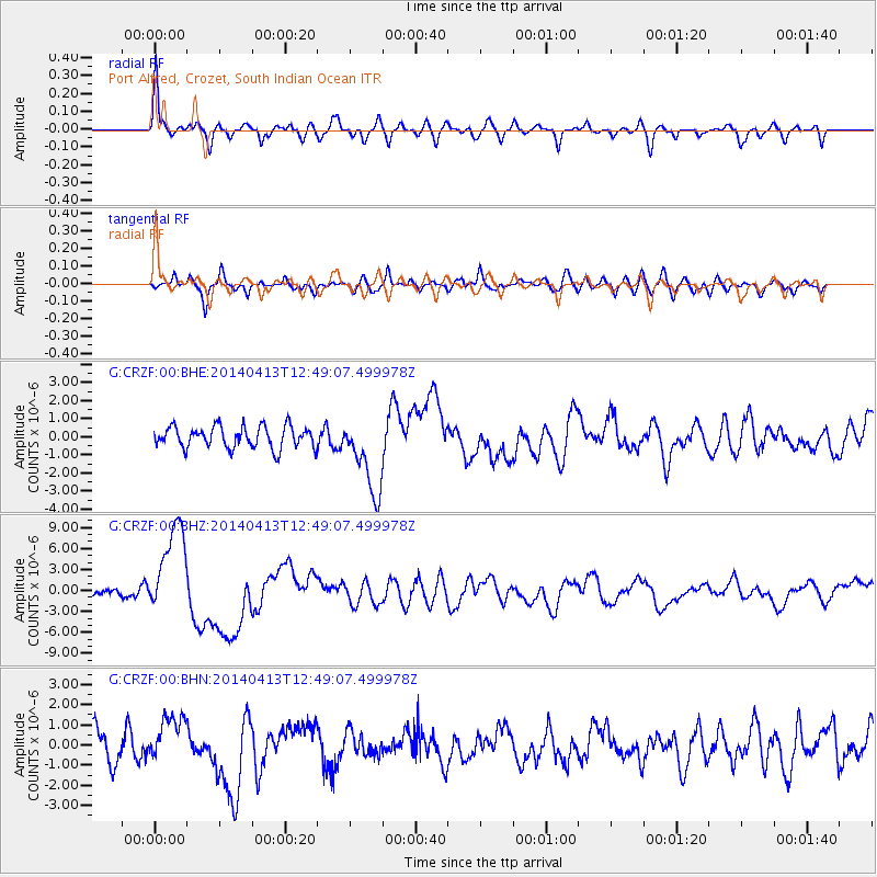
Signal To Noise
| Channel | StoN | STA | LTA |
| G:CRZF:00:BHZ:20140413T12:49:07.499978Z | 11.816626 | 6.6333737E-6 | 5.613594E-7 |
| G:CRZF:00:BHN:20140413T12:49:07.499978Z | 1.4229664 | 1.1549623E-6 | 8.1165825E-7 |
| G:CRZF:00:BHE:20140413T12:49:07.499978Z | 3.616266 | 2.159989E-6 | 5.972982E-7 |
| Arrivals |
| Ps | 1.6 SECOND |
| PpPs | 7.0 SECOND |
| PsPs/PpSs | 8.6 SECOND |


