You are here: Home > Network List > G - GEOSCOPE Stations List
> Station PPTF Pamatai - Papeete - Tahiti island - French Polynesia, France > Earthquake Result Viewer
PPTF Pamatai - Papeete - Tahiti island - French Polynesia, France - Earthquake Result Viewer

| Earthquake location: |
Solomon Islands |
| Earthquake latitude/longitude: |
-11.5/162.1 |
| Earthquake time(UTC): |
2014/04/13 (103) 12:36:18 GMT |
| Earthquake Depth: |
35 km |
| Earthquake Magnitude: |
7.4 MWW, 7.7 MI |
| Earthquake Catalog/Contributor: |
NEIC PDE/NEIC COMCAT |
|
| Network: |
G GEOSCOPE |
| Station: |
PPTF Pamatai - Papeete - Tahiti island - French Polynesia, France |
| Lat/Lon: |
17.59 S/149.57 W |
| Elevation: |
705 m |
|
| Distance: |
47.1 deg |
| Az: |
103.371 deg |
| Baz: |
270.585 deg |
| Ray Param: |
0.070129916 |
| Estimated Moho Depth: |
51.5 km |
| Estimated Crust Vp/Vs: |
1.85 |
| Assumed Crust Vp: |
4.24 km/s |
| Estimated Crust Vs: |
2.289 km/s |
| Estimated Crust Poisson's Ratio: |
0.29 |
|
| Radial Match: |
88.29912 % |
| Radial Bump: |
400 |
| Transverse Match: |
65.50883 % |
| Transverse Bump: |
400 |
| SOD ConfigId: |
626651 |
| Insert Time: |
2014-04-27 12:54:57.181 +0000 |
| GWidth: |
2.5 |
| Max Bumps: |
400 |
| Tol: |
0.001 |
|
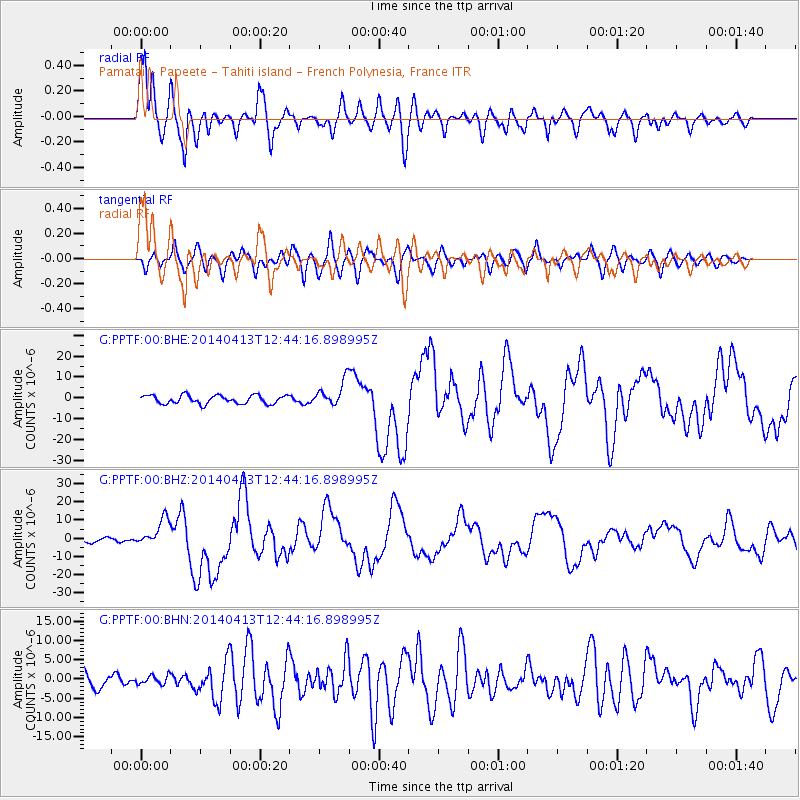
Signal To Noise
| Channel | StoN | STA | LTA |
| G:PPTF:00:BHZ:20140413T12:44:16.898995Z | 3.5692697 | 7.4986197E-6 | 2.1008834E-6 |
| G:PPTF:00:BHN:20140413T12:44:16.898995Z | 0.64329565 | 1.1596603E-6 | 1.8026864E-6 |
| G:PPTF:00:BHE:20140413T12:44:16.898995Z | 2.9794555 | 6.059478E-6 | 2.0337536E-6 |
| Arrivals |
| Ps | 11 SECOND |
| PpPs | 34 SECOND |
| PsPs/PpSs | 44 SECOND |


