You are here: Home > Network List > II - Global Seismograph Network (GSN - IRIS/IDA) Stations List
> Station XPFO Pinon Flat, California, USA > Earthquake Result Viewer
XPFO Pinon Flat, California, USA - Earthquake Result Viewer

| Earthquake location: |
Solomon Islands |
| Earthquake latitude/longitude: |
-11.5/162.1 |
| Earthquake time(UTC): |
2014/04/13 (103) 12:36:18 GMT |
| Earthquake Depth: |
35 km |
| Earthquake Magnitude: |
7.4 MWW, 7.7 MI |
| Earthquake Catalog/Contributor: |
NEIC PDE/NEIC COMCAT |
|
| Network: |
II Global Seismograph Network (GSN - IRIS/IDA) |
| Station: |
XPFO Pinon Flat, California, USA |
| Lat/Lon: |
33.61 N/116.46 W |
| Elevation: |
1280 m |
|
| Distance: |
89.3 deg |
| Az: |
55.626 deg |
| Baz: |
255.836 deg |
| Ray Param: |
0.041921895 |
| Estimated Moho Depth: |
29.25 km |
| Estimated Crust Vp/Vs: |
1.66 |
| Assumed Crust Vp: |
6.264 km/s |
| Estimated Crust Vs: |
3.768 km/s |
| Estimated Crust Poisson's Ratio: |
0.22 |
|
| Radial Match: |
94.622734 % |
| Radial Bump: |
400 |
| Transverse Match: |
89.16468 % |
| Transverse Bump: |
400 |
| SOD ConfigId: |
626651 |
| Insert Time: |
2014-04-27 12:56:12.838 +0000 |
| GWidth: |
2.5 |
| Max Bumps: |
400 |
| Tol: |
0.001 |
|
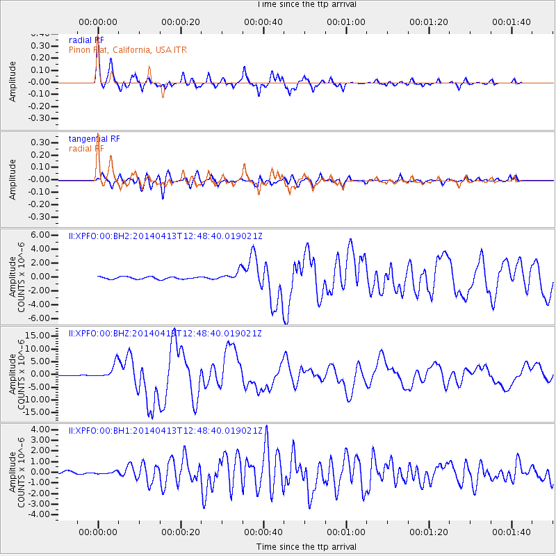
Signal To Noise
| Channel | StoN | STA | LTA |
| II:XPFO:00:BHZ:20140413T12:48:40.019021Z | 20.301542 | 3.2287E-6 | 1.5903719E-7 |
| II:XPFO:00:BH1:20140413T12:48:40.019021Z | 0.9417262 | 1.840547E-7 | 1.9544396E-7 |
| II:XPFO:00:BH2:20140413T12:48:40.019021Z | 4.5344872 | 7.88391E-7 | 1.7386552E-7 |
| Arrivals |
| Ps | 3.2 SECOND |
| PpPs | 12 SECOND |
| PsPs/PpSs | 15 SECOND |


