You are here: Home > Network List > II - Global Seismograph Network (GSN - IRIS/IDA) Stations List
> Station KDAK Kodiak Island, Alaska, USA > Earthquake Result Viewer
KDAK Kodiak Island, Alaska, USA - Earthquake Result Viewer
| Earthquake location: |
Vanuatu Islands |
| Earthquake latitude/longitude: |
-20.9/169.8 |
| Earthquake time(UTC): |
2003/04/27 (117) 16:03:40 GMT |
| Earthquake Depth: |
77 km |
| Earthquake Magnitude: |
6.0 MB, 6.3 MW, 6.2 MW |
| Earthquake Catalog/Contributor: |
WHDF/NEIC |
|
| Network: |
II Global Seismograph Network (GSN - IRIS/IDA) |
| Station: |
KDAK Kodiak Island, Alaska, USA |
| Lat/Lon: |
57.78 N/152.58 W |
| Elevation: |
152 m |
|
| Distance: |
84.5 deg |
| Az: |
19.19 deg |
| Baz: |
214.998 deg |
| Ray Param: |
0.04530498 |
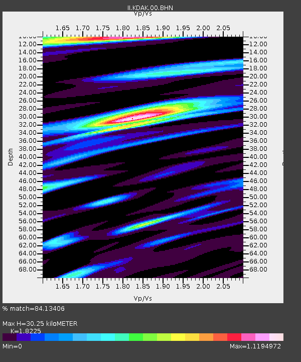
| Estimated Moho Depth: |
30.25 km |
| Estimated Crust Vp/Vs: |
1.82 |
| Assumed Crust Vp: |
6.134 km/s |
| Estimated Crust Vs: |
3.366 km/s |
| Estimated Crust Poisson's Ratio: |
0.28 |
|
| Radial Match: |
84.13406 % |
| Radial Bump: |
400 |
| Transverse Match: |
65.90179 % |
| Transverse Bump: |
400 |
| SOD ConfigId: |
4714 |
| Insert Time: |
2010-03-01 20:56:38.440 +0000 |
| GWidth: |
2.5 |
| Max Bumps: |
400 |
| Tol: |
0.001 |
|
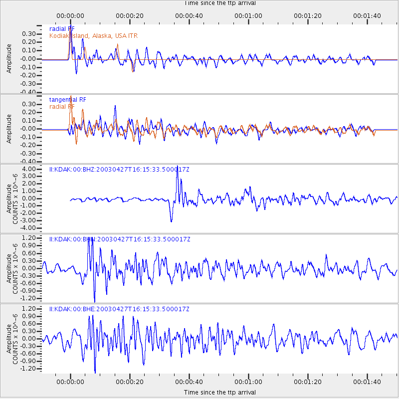
Signal To Noise
| Channel | StoN | STA | LTA |
| II:KDAK:00:BHN:20030427T16:15:33.500017Z | 1.6453278 | 2.4181048E-7 | 1.4696798E-7 |
| II:KDAK:00:BHE:20030427T16:15:33.500017Z | 1.9666672 | 3.6943956E-7 | 1.8785057E-7 |
| II:KDAK:00:BHZ:20030427T16:15:33.500017Z | 6.7411203 | 1.0737654E-6 | 1.5928589E-7 |
| Arrivals |
| Ps | 4.1 SECOND |
| PpPs | 14 SECOND |
| PsPs/PpSs | 18 SECOND |


