You are here: Home > Network List > IW - Intermountain West Stations List
> Station IMW Indian Meadow, Wyoming, USA > Earthquake Result Viewer
IMW Indian Meadow, Wyoming, USA - Earthquake Result Viewer
| Earthquake location: |
Solomon Islands |
| Earthquake latitude/longitude: |
-11.5/162.1 |
| Earthquake time(UTC): |
2014/04/13 (103) 12:36:18 GMT |
| Earthquake Depth: |
35 km |
| Earthquake Magnitude: |
7.4 MWW, 7.7 MI |
| Earthquake Catalog/Contributor: |
NEIC PDE/NEIC COMCAT |
|
| Network: |
IW Intermountain West |
| Station: |
IMW Indian Meadow, Wyoming, USA |
| Lat/Lon: |
43.90 N/110.94 W |
| Elevation: |
2646 m |
|
| Distance: |
95.7 deg |
| Az: |
46.509 deg |
| Baz: |
259.687 deg |
| Ray Param: |
0.04070044 |
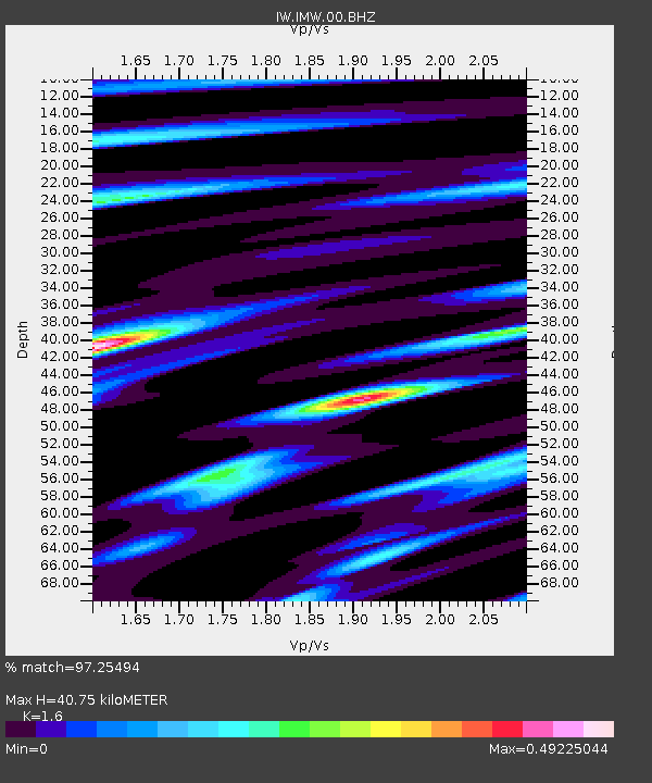
| Estimated Moho Depth: |
40.75 km |
| Estimated Crust Vp/Vs: |
1.60 |
| Assumed Crust Vp: |
6.207 km/s |
| Estimated Crust Vs: |
3.879 km/s |
| Estimated Crust Poisson's Ratio: |
0.18 |
|
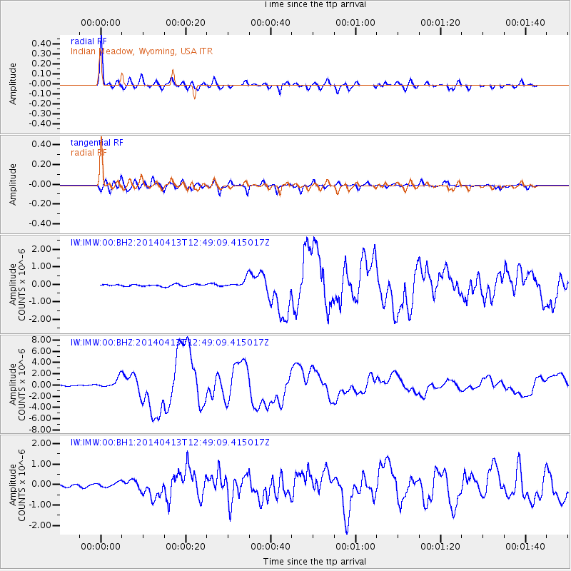
| Radial Match: |
97.25494 % |
| Radial Bump: |
400 |
| Transverse Match: |
93.74599 % |
| Transverse Bump: |
400 |
| SOD ConfigId: |
626651 |
| Insert Time: |
2014-04-27 12:57:47.390 +0000 |
| GWidth: |
2.5 |
| Max Bumps: |
400 |
| Tol: |
0.001 |
|
Signal To Noise
| Channel | StoN | STA | LTA |
| IW:IMW:00:BHZ:20140413T12:49:09.415017Z | 15.052818 | 9.298863E-7 | 6.17749E-8 |
| IW:IMW:00:BH1:20140413T12:49:09.415017Z | 2.6428182 | 1.2147146E-7 | 4.596285E-8 |
| IW:IMW:00:BH2:20140413T12:49:09.415017Z | 5.0165987 | 2.6578158E-7 | 5.2980436E-8 |
| Arrivals |
| Ps | 4.0 SECOND |
| PpPs | 17 SECOND |
| PsPs/PpSs | 21 SECOND |


