You are here: Home > Network List > NN - Western Great Basin/Eastern Sierra Nevada Stations List
> Station RUB Rubicon Trail, California w84 > Earthquake Result Viewer
RUB Rubicon Trail, California w84 - Earthquake Result Viewer
| Earthquake location: |
Solomon Islands |
| Earthquake latitude/longitude: |
-11.5/162.1 |
| Earthquake time(UTC): |
2014/04/13 (103) 12:36:18 GMT |
| Earthquake Depth: |
35 km |
| Earthquake Magnitude: |
7.4 MWW, 7.7 MI |
| Earthquake Catalog/Contributor: |
NEIC PDE/NEIC COMCAT |
|
| Network: |
NN Western Great Basin/Eastern Sierra Nevada |
| Station: |
RUB Rubicon Trail, California w84 |
| Lat/Lon: |
39.05 N/120.15 W |
| Elevation: |
2045 m |
|
| Distance: |
87.8 deg |
| Az: |
49.6 deg |
| Baz: |
253.499 deg |
| Ray Param: |
0.042991526 |
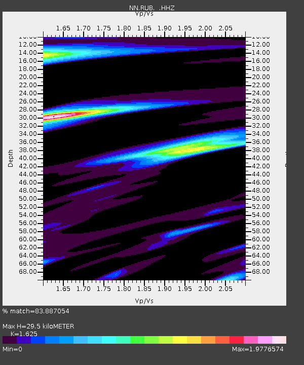
| Estimated Moho Depth: |
29.5 km |
| Estimated Crust Vp/Vs: |
1.62 |
| Assumed Crust Vp: |
6.597 km/s |
| Estimated Crust Vs: |
4.06 km/s |
| Estimated Crust Poisson's Ratio: |
0.20 |
|
| Radial Match: |
83.887054 % |
| Radial Bump: |
400 |
| Transverse Match: |
72.86952 % |
| Transverse Bump: |
400 |
| SOD ConfigId: |
626651 |
| Insert Time: |
2014-04-27 12:59:14.017 +0000 |
| GWidth: |
2.5 |
| Max Bumps: |
400 |
| Tol: |
0.001 |
|

Signal To Noise
| Channel | StoN | STA | LTA |
| NN:RUB: :HHZ:20140413T12:48:33.155007Z | 23.726023 | 3.4674376E-6 | 1.4614491E-7 |
| NN:RUB: :HHN:20140413T12:48:33.155007Z | 1.5135947 | 3.339495E-7 | 2.2063337E-7 |
| NN:RUB: :HHE:20140413T12:48:33.155007Z | 6.7588205 | 8.7301265E-7 | 1.2916642E-7 |
| Arrivals |
| Ps | 2.9 SECOND |
| PpPs | 11 SECOND |
| PsPs/PpSs | 14 SECOND |


