You are here: Home > Network List > II - Global Seismograph Network (GSN - IRIS/IDA) Stations List
> Station KDAK Kodiak Island, Alaska, USA > Earthquake Result Viewer
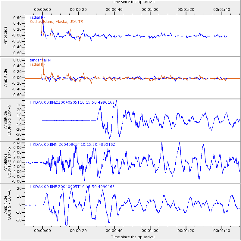
KDAK Kodiak Island, Alaska, USA - Earthquake Result Viewer
| Earthquake location: |
Near S. Coast Of Western Honshu |
| Earthquake latitude/longitude: |
33.1/136.6 |
| Earthquake time(UTC): |
2004/09/05 (249) 10:07:07 GMT |
| Earthquake Depth: |
14 km |
| Earthquake Magnitude: |
6.7 MB, 7.0 MS, 7.2 MW, 7.0 MW |
| Earthquake Catalog/Contributor: |
WHDF/NEIC |
|
| Network: |
II Global Seismograph Network (GSN - IRIS/IDA) |
| Station: |
KDAK Kodiak Island, Alaska, USA |
| Lat/Lon: |
57.78 N/152.58 W |
| Elevation: |
152 m |
|
| Distance: |
52.7 deg |
| Az: |
39.516 deg |
| Baz: |
274.164 deg |
| Ray Param: |
0.06660714 |
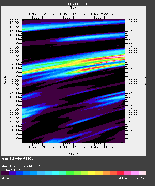
| Estimated Moho Depth: |
27.75 km |
| Estimated Crust Vp/Vs: |
2.09 |
| Assumed Crust Vp: |
6.134 km/s |
| Estimated Crust Vs: |
2.931 km/s |
| Estimated Crust Poisson's Ratio: |
0.35 |
|
| Radial Match: |
96.93301 % |
| Radial Bump: |
291 |
| Transverse Match: |
88.260826 % |
| Transverse Bump: |
400 |
| SOD ConfigId: |
2459 |
| Insert Time: |
2010-03-01 20:57:46.753 +0000 |
| GWidth: |
2.5 |
| Max Bumps: |
400 |
| Tol: |
0.001 |
|
Signal To Noise
| Channel | StoN | STA | LTA |
| II:KDAK:00:BHN:20040905T10:15:50.499016Z | 4.1149936 | 8.951433E-7 | 2.1753213E-7 |
| II:KDAK:00:BHE:20040905T10:15:50.499016Z | 27.872416 | 7.1462737E-6 | 2.5639235E-7 |
| II:KDAK:00:BHZ:20040905T10:15:50.499016Z | 61.287746 | 1.3470394E-5 | 2.1978936E-7 |
| Arrivals |
| Ps | 5.2 SECOND |
| PpPs | 13 SECOND |
| PsPs/PpSs | 19 SECOND |


