You are here: Home > Network List > S - Seismographs in Schools Projects Stations List
> Station AUKAL John Paul College, Kalgoorlie, WA > Earthquake Result Viewer
AUKAL John Paul College, Kalgoorlie, WA - Earthquake Result Viewer
| Earthquake location: |
Solomon Islands |
| Earthquake latitude/longitude: |
-11.5/162.1 |
| Earthquake time(UTC): |
2014/04/13 (103) 12:36:18 GMT |
| Earthquake Depth: |
35 km |
| Earthquake Magnitude: |
7.4 MWW, 7.7 MI |
| Earthquake Catalog/Contributor: |
NEIC PDE/NEIC COMCAT |
|
| Network: |
S Seismographs in Schools Projects |
| Station: |
AUKAL John Paul College, Kalgoorlie, WA |
| Lat/Lon: |
30.76 S/121.48 E |
| Elevation: |
373 m |
|
| Distance: |
42.2 deg |
| Az: |
236.548 deg |
| Baz: |
71.849 deg |
| Ray Param: |
0.07326499 |
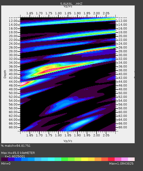
| Estimated Moho Depth: |
45.0 km |
| Estimated Crust Vp/Vs: |
1.60 |
| Assumed Crust Vp: |
6.459 km/s |
| Estimated Crust Vs: |
4.031 km/s |
| Estimated Crust Poisson's Ratio: |
0.18 |
|
| Radial Match: |
94.81751 % |
| Radial Bump: |
322 |
| Transverse Match: |
89.59364 % |
| Transverse Bump: |
400 |
| SOD ConfigId: |
626651 |
| Insert Time: |
2014-04-27 13:01:16.176 +0000 |
| GWidth: |
2.5 |
| Max Bumps: |
400 |
| Tol: |
0.001 |
|

Signal To Noise
| Channel | StoN | STA | LTA |
| S:AUKAL: :HHZ:20140413T12:43:37.430001Z | 46.381523 | 6.492829E-5 | 1.399874E-6 |
| S:AUKAL: :HHN:20140413T12:43:37.430001Z | 4.011794 | 6.1144115E-6 | 1.524109E-6 |
| S:AUKAL: :HHE:20140413T12:43:37.430001Z | 17.73034 | 4.130829E-5 | 2.3298082E-6 |
| Arrivals |
| Ps | 4.5 SECOND |
| PpPs | 17 SECOND |
| PsPs/PpSs | 21 SECOND |


