You are here: Home > Network List > II - Global Seismograph Network (GSN - IRIS/IDA) Stations List
> Station KDAK Kodiak Island, Alaska, USA > Earthquake Result Viewer
KDAK Kodiak Island, Alaska, USA - Earthquake Result Viewer

| Earthquake location: |
Taiwan Region |
| Earthquake latitude/longitude: |
22.7/121.5 |
| Earthquake time(UTC): |
2004/05/19 (140) 07:04:11 GMT |
| Earthquake Depth: |
20 km |
| Earthquake Magnitude: |
5.8 MB, 6.1 MS, 6.2 MW, 6.1 MW |
| Earthquake Catalog/Contributor: |
WHDF/NEIC |
|
| Network: |
II Global Seismograph Network (GSN - IRIS/IDA) |
| Station: |
KDAK Kodiak Island, Alaska, USA |
| Lat/Lon: |
57.78 N/152.58 W |
| Elevation: |
152 m |
|
| Distance: |
69.0 deg |
| Az: |
34.921 deg |
| Baz: |
279.223 deg |
| Ray Param: |
0.055931978 |
| Estimated Moho Depth: |
28.0 km |
| Estimated Crust Vp/Vs: |
1.93 |
| Assumed Crust Vp: |
6.134 km/s |
| Estimated Crust Vs: |
3.17 km/s |
| Estimated Crust Poisson's Ratio: |
0.32 |
|
| Radial Match: |
85.25967 % |
| Radial Bump: |
400 |
| Transverse Match: |
70.328514 % |
| Transverse Bump: |
400 |
| SOD ConfigId: |
2459 |
| Insert Time: |
2010-03-01 20:57:56.480 +0000 |
| GWidth: |
2.5 |
| Max Bumps: |
400 |
| Tol: |
0.001 |
|
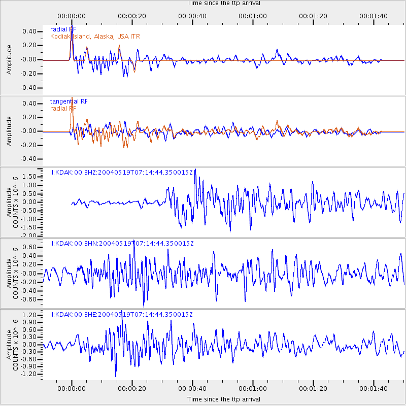
Signal To Noise
| Channel | StoN | STA | LTA |
| II:KDAK:00:BHN:20040519T07:14:44.350015Z | 1.4340366 | 1.2800007E-7 | 8.925857E-8 |
| II:KDAK:00:BHE:20040519T07:14:44.350015Z | 2.0537794 | 2.0090084E-7 | 9.782007E-8 |
| II:KDAK:00:BHZ:20040519T07:14:44.350015Z | 4.5260167 | 4.532723E-7 | 1.0014817E-7 |
| Arrivals |
| Ps | 4.4 SECOND |
| PpPs | 13 SECOND |
| PsPs/PpSs | 17 SECOND |


