You are here: Home > Network List > TA - USArray Transportable Network (new EarthScope stations) Stations List
> Station A36M Sachs Harbour, NT, CAN > Earthquake Result Viewer
A36M Sachs Harbour, NT, CAN - Earthquake Result Viewer
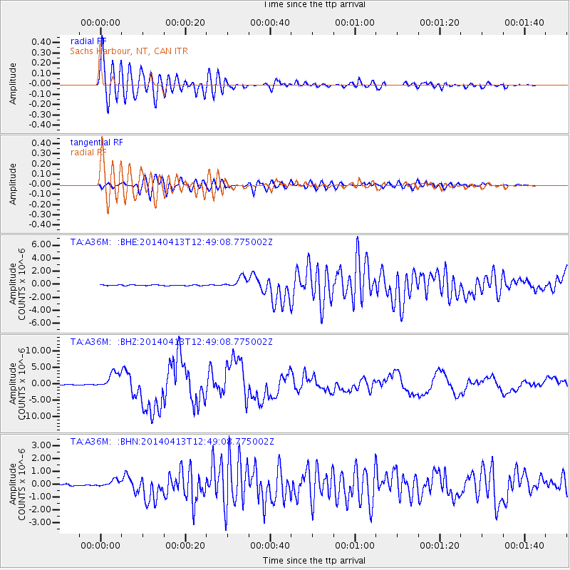
| Earthquake location: |
Solomon Islands |
| Earthquake latitude/longitude: |
-11.5/162.1 |
| Earthquake time(UTC): |
2014/04/13 (103) 12:36:18 GMT |
| Earthquake Depth: |
35 km |
| Earthquake Magnitude: |
7.4 MWW, 7.7 MI |
| Earthquake Catalog/Contributor: |
NEIC PDE/NEIC COMCAT |
|
| Network: |
TA USArray Transportable Network (new EarthScope stations) |
| Station: |
A36M Sachs Harbour, NT, CAN |
| Lat/Lon: |
71.99 N/125.25 W |
| Elevation: |
32 m |
|
| Distance: |
95.5 deg |
| Az: |
17.362 deg |
| Baz: |
250.106 deg |
| Ray Param: |
0.040737353 |
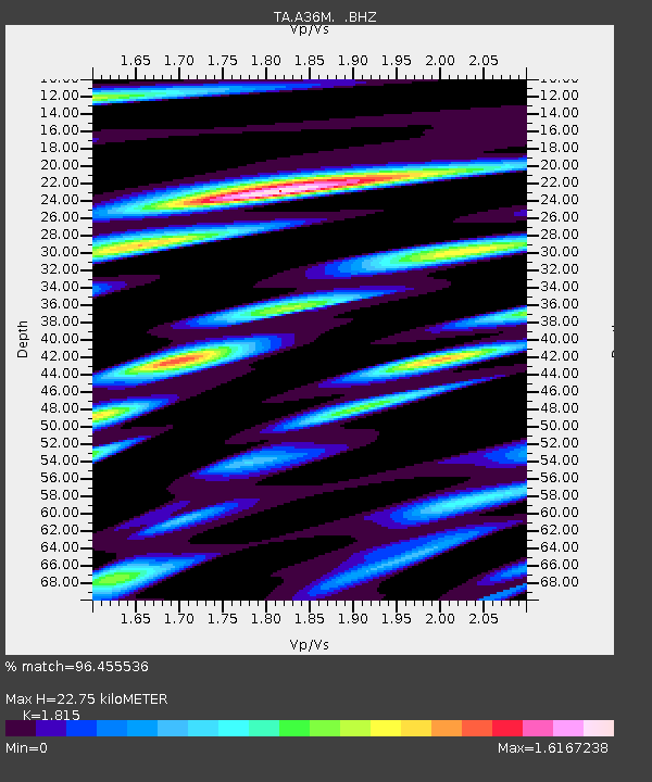
| Estimated Moho Depth: |
22.75 km |
| Estimated Crust Vp/Vs: |
1.82 |
| Assumed Crust Vp: |
6.24 km/s |
| Estimated Crust Vs: |
3.438 km/s |
| Estimated Crust Poisson's Ratio: |
0.28 |
|
| Radial Match: |
96.455536 % |
| Radial Bump: |
400 |
| Transverse Match: |
88.36912 % |
| Transverse Bump: |
400 |
| SOD ConfigId: |
626651 |
| Insert Time: |
2014-04-27 13:01:48.103 +0000 |
| GWidth: |
2.5 |
| Max Bumps: |
400 |
| Tol: |
0.001 |
|
Signal To Noise
| Channel | StoN | STA | LTA |
| TA:A36M: :BHZ:20140413T12:49:08.775002Z | 25.766672 | 2.6758403E-6 | 1.038489E-7 |
| TA:A36M: :BHN:20140413T12:49:08.775002Z | 2.7839165 | 2.9426744E-7 | 1.05702675E-7 |
| TA:A36M: :BHE:20140413T12:49:08.775002Z | 14.977512 | 8.637489E-7 | 5.7669716E-8 |
| Arrivals |
| Ps | 3.0 SECOND |
| PpPs | 10 SECOND |
| PsPs/PpSs | 13 SECOND |


