You are here: Home > Network List > TA - USArray Transportable Network (new EarthScope stations) Stations List
> Station F04D Rainier, OR, USA > Earthquake Result Viewer
F04D Rainier, OR, USA - Earthquake Result Viewer
| Earthquake location: |
Solomon Islands |
| Earthquake latitude/longitude: |
-11.5/162.1 |
| Earthquake time(UTC): |
2014/04/13 (103) 12:36:18 GMT |
| Earthquake Depth: |
35 km |
| Earthquake Magnitude: |
7.4 MWW, 7.7 MI |
| Earthquake Catalog/Contributor: |
NEIC PDE/NEIC COMCAT |
|
| Network: |
TA USArray Transportable Network (new EarthScope stations) |
| Station: |
F04D Rainier, OR, USA |
| Lat/Lon: |
46.08 N/123.01 W |
| Elevation: |
236 m |
|
| Distance: |
87.9 deg |
| Az: |
42.26 deg |
| Baz: |
251.299 deg |
| Ray Param: |
0.042908058 |
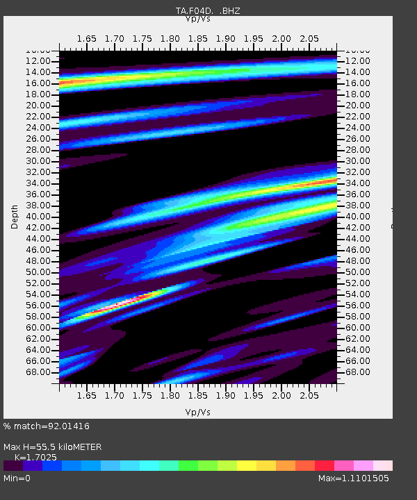
| Estimated Moho Depth: |
55.5 km |
| Estimated Crust Vp/Vs: |
1.70 |
| Assumed Crust Vp: |
6.566 km/s |
| Estimated Crust Vs: |
3.857 km/s |
| Estimated Crust Poisson's Ratio: |
0.24 |
|
| Radial Match: |
92.01416 % |
| Radial Bump: |
400 |
| Transverse Match: |
91.30865 % |
| Transverse Bump: |
400 |
| SOD ConfigId: |
626651 |
| Insert Time: |
2014-04-27 13:02:07.481 +0000 |
| GWidth: |
2.5 |
| Max Bumps: |
400 |
| Tol: |
0.001 |
|

Signal To Noise
| Channel | StoN | STA | LTA |
| TA:F04D: :BHZ:20140413T12:48:33.699014Z | 13.543806 | 4.448011E-6 | 3.2841663E-7 |
| TA:F04D: :BHN:20140413T12:48:33.699014Z | 0.7279244 | 3.162202E-7 | 4.344135E-7 |
| TA:F04D: :BHE:20140413T12:48:33.699014Z | 4.383203 | 1.3969332E-6 | 3.1870144E-7 |
| Arrivals |
| Ps | 6.1 SECOND |
| PpPs | 22 SECOND |
| PsPs/PpSs | 28 SECOND |


