You are here: Home > Network List > IU - Global Seismograph Network (GSN - IRIS/USGS) Stations List
> Station POHA Pohakuloa, Hawaii, USA > Earthquake Result Viewer
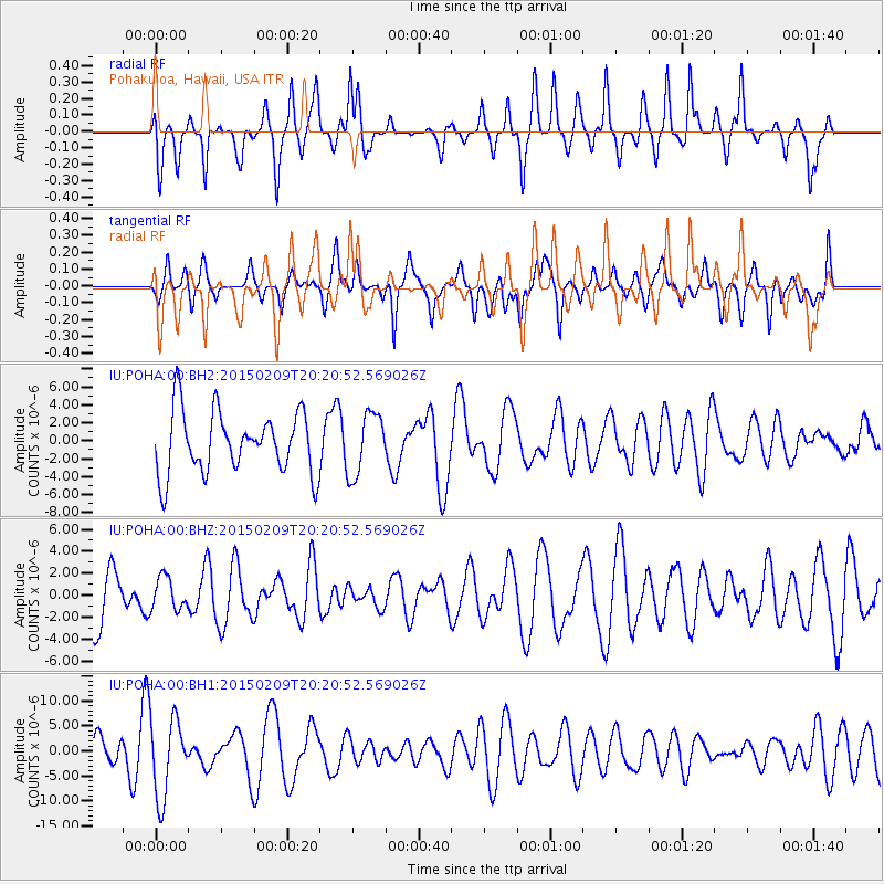
POHA Pohakuloa, Hawaii, USA - Earthquake Result Viewer
*The percent match for this event was below the threshold and hence no stack was calculated.
| Earthquake location: |
Kuril Islands |
| Earthquake latitude/longitude: |
44.0/146.9 |
| Earthquake time(UTC): |
2015/02/09 (040) 20:12:13 GMT |
| Earthquake Depth: |
89 km |
| Earthquake Magnitude: |
4.9 mb |
| Earthquake Catalog/Contributor: |
ISC/ISC |
|
| Network: |
IU Global Seismograph Network (GSN - IRIS/USGS) |
| Station: |
POHA Pohakuloa, Hawaii, USA |
| Lat/Lon: |
19.76 N/155.53 W |
| Elevation: |
1990 m |
|
| Distance: |
53.3 deg |
| Az: |
97.686 deg |
| Baz: |
310.595 deg |
| Ray Param: |
$rayparam |
*The percent match for this event was below the threshold and hence was not used in the summary stack. |
|
| Radial Match: |
49.88158 % |
| Radial Bump: |
272 |
| Transverse Match: |
32.09106 % |
| Transverse Bump: |
347 |
| SOD ConfigId: |
7019011 |
| Insert Time: |
2019-04-16 17:29:34.075 +0000 |
| GWidth: |
2.5 |
| Max Bumps: |
400 |
| Tol: |
0.001 |
|
Signal To Noise
| Channel | StoN | STA | LTA |
| IU:POHA:00:BHZ:20150209T20:20:52.569026Z | 0.7039117 | 1.4660984E-6 | 2.0827872E-6 |
| IU:POHA:00:BH1:20150209T20:20:52.569026Z | 2.690773 | 7.762312E-6 | 2.8847885E-6 |
| IU:POHA:00:BH2:20150209T20:20:52.569026Z | 1.004571 | 3.4631444E-6 | 3.4473865E-6 |
| Arrivals |
| Ps | |
| PpPs | |
| PsPs/PpSs | |


