You are here: Home > Network List > II - Global Seismograph Network (GSN - IRIS/IDA) Stations List
> Station KDAK Kodiak Island, Alaska, USA > Earthquake Result Viewer
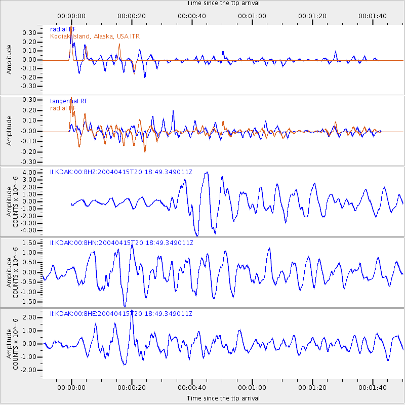
KDAK Kodiak Island, Alaska, USA - Earthquake Result Viewer

| Earthquake location: |
Vanuatu Islands |
| Earthquake latitude/longitude: |
-19.4/169.6 |
| Earthquake time(UTC): |
2004/04/15 (106) 20:06:55 GMT |
| Earthquake Depth: |
10 km |
| Earthquake Magnitude: |
5.8 MB, 6.2 MS, 6.3 MW, 6.2 MW |
| Earthquake Catalog/Contributor: |
WHDF/NEIC |
|
| Network: |
II Global Seismograph Network (GSN - IRIS/IDA) |
| Station: |
KDAK Kodiak Island, Alaska, USA |
| Lat/Lon: |
57.78 N/152.58 W |
| Elevation: |
152 m |
|
| Distance: |
83.0 deg |
| Az: |
19.309 deg |
| Baz: |
215.643 deg |
| Ray Param: |
0.04647136 |
| Estimated Moho Depth: |
27.25 km |
| Estimated Crust Vp/Vs: |
1.99 |
| Assumed Crust Vp: |
6.134 km/s |
| Estimated Crust Vs: |
3.082 km/s |
| Estimated Crust Poisson's Ratio: |
0.33 |
|
| Radial Match: |
89.33879 % |
| Radial Bump: |
400 |
| Transverse Match: |
67.33755 % |
| Transverse Bump: |
400 |
| SOD ConfigId: |
2459 |
| Insert Time: |
2010-03-01 20:58:02.699 +0000 |
| GWidth: |
2.5 |
| Max Bumps: |
400 |
| Tol: |
0.001 |
|
Signal To Noise
| Channel | StoN | STA | LTA |
| II:KDAK:00:BHN:20040415T20:18:49.349011Z | 1.10388 | 3.5474454E-7 | 3.2136148E-7 |
| II:KDAK:00:BHE:20040415T20:18:49.349011Z | 0.9899123 | 2.7799166E-7 | 2.8082454E-7 |
| II:KDAK:00:BHZ:20040415T20:18:49.349011Z | 1.5405275 | 5.737899E-7 | 3.724633E-7 |
| Arrivals |
| Ps | 4.5 SECOND |
| PpPs | 13 SECOND |
| PsPs/PpSs | 17 SECOND |


