You are here: Home > Network List > II - Global Seismograph Network (GSN - IRIS/IDA) Stations List
> Station KDAK Kodiak Island, Alaska, USA > Earthquake Result Viewer
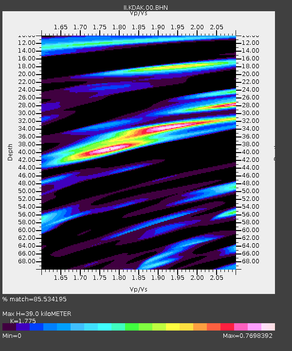
KDAK Kodiak Island, Alaska, USA - Earthquake Result Viewer
| Earthquake location: |
Minahassa Peninsula, Sulawesi |
| Earthquake latitude/longitude: |
0.8/124.7 |
| Earthquake time(UTC): |
2004/06/30 (182) 23:37:25 GMT |
| Earthquake Depth: |
91 km |
| Earthquake Magnitude: |
6.0 MB, 6.3 MW, 6.2 MW |
| Earthquake Catalog/Contributor: |
WHDF/NEIC |
|
| Network: |
II Global Seismograph Network (GSN - IRIS/IDA) |
| Station: |
KDAK Kodiak Island, Alaska, USA |
| Lat/Lon: |
57.78 N/152.58 W |
| Elevation: |
152 m |
|
| Distance: |
85.4 deg |
| Az: |
32.211 deg |
| Baz: |
264.241 deg |
| Ray Param: |
0.044587653 |
| Estimated Moho Depth: |
39.0 km |
| Estimated Crust Vp/Vs: |
1.77 |
| Assumed Crust Vp: |
6.134 km/s |
| Estimated Crust Vs: |
3.456 km/s |
| Estimated Crust Poisson's Ratio: |
0.27 |
|
| Radial Match: |
85.534195 % |
| Radial Bump: |
400 |
| Transverse Match: |
74.80473 % |
| Transverse Bump: |
400 |
| SOD ConfigId: |
2459 |
| Insert Time: |
2010-03-01 20:58:19.255 +0000 |
| GWidth: |
2.5 |
| Max Bumps: |
400 |
| Tol: |
0.001 |
|

Signal To Noise
| Channel | StoN | STA | LTA |
| II:KDAK:00:BHN:20040630T23:49:21.749011Z | 1.4651853 | 2.3690859E-7 | 1.616919E-7 |
| II:KDAK:00:BHE:20040630T23:49:21.749011Z | 1.4215944 | 3.0601967E-7 | 2.1526512E-7 |
| II:KDAK:00:BHZ:20040630T23:49:21.749011Z | 2.8505094 | 6.2922214E-7 | 2.2074025E-7 |
| Arrivals |
| Ps | 5.0 SECOND |
| PpPs | 17 SECOND |
| PsPs/PpSs | 22 SECOND |


