You are here: Home > Network List > US - United States National Seismic Network Stations List
> Station BW06 Boulder Array Site 6 (Pinedale), Wyoming, USA > Earthquake Result Viewer
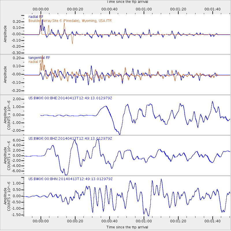
BW06 Boulder Array Site 6 (Pinedale), Wyoming, USA - Earthquake Result Viewer
| Earthquake location: |
Solomon Islands |
| Earthquake latitude/longitude: |
-11.5/162.1 |
| Earthquake time(UTC): |
2014/04/13 (103) 12:36:18 GMT |
| Earthquake Depth: |
35 km |
| Earthquake Magnitude: |
7.4 MWW, 7.7 MI |
| Earthquake Catalog/Contributor: |
NEIC PDE/NEIC COMCAT |
|
| Network: |
US United States National Seismic Network |
| Station: |
BW06 Boulder Array Site 6 (Pinedale), Wyoming, USA |
| Lat/Lon: |
42.77 N/109.56 W |
| Elevation: |
2224 m |
|
| Distance: |
96.5 deg |
| Az: |
47.803 deg |
| Baz: |
260.494 deg |
| Ray Param: |
0.04048378 |
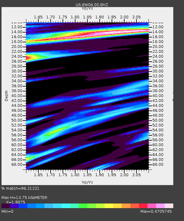
| Estimated Moho Depth: |
13.75 km |
| Estimated Crust Vp/Vs: |
1.99 |
| Assumed Crust Vp: |
6.161 km/s |
| Estimated Crust Vs: |
3.1 km/s |
| Estimated Crust Poisson's Ratio: |
0.33 |
|
| Radial Match: |
96.21221 % |
| Radial Bump: |
400 |
| Transverse Match: |
90.47205 % |
| Transverse Bump: |
400 |
| SOD ConfigId: |
626651 |
| Insert Time: |
2014-04-27 13:03:47.075 +0000 |
| GWidth: |
2.5 |
| Max Bumps: |
400 |
| Tol: |
0.001 |
|
Signal To Noise
| Channel | StoN | STA | LTA |
| US:BW06:00:BHZ:20140413T12:49:13.012979Z | 25.628775 | 1.4712325E-6 | 5.7405497E-8 |
| US:BW06:00:BHN:20140413T12:49:13.012979Z | 0.9704782 | 4.7708667E-8 | 4.9159958E-8 |
| US:BW06:00:BHE:20140413T12:49:13.012979Z | 6.538795 | 2.9580772E-7 | 4.5238874E-8 |
| Arrivals |
| Ps | 2.2 SECOND |
| PpPs | 6.6 SECOND |
| PsPs/PpSs | 8.8 SECOND |


