You are here: Home > Network List > TA - USArray Transportable Network (new EarthScope stations) Stations List
> Station I61A Oroboro, Fairlee, VT, USA > Earthquake Result Viewer
I61A Oroboro, Fairlee, VT, USA - Earthquake Result Viewer
| Earthquake location: |
Kuril Islands |
| Earthquake latitude/longitude: |
44.0/146.9 |
| Earthquake time(UTC): |
2015/02/09 (040) 20:12:13 GMT |
| Earthquake Depth: |
89 km |
| Earthquake Magnitude: |
4.9 mb |
| Earthquake Catalog/Contributor: |
ISC/ISC |
|
| Network: |
TA USArray Transportable Network (new EarthScope stations) |
| Station: |
I61A Oroboro, Fairlee, VT, USA |
| Lat/Lon: |
43.93 N/72.21 W |
| Elevation: |
287 m |
|
| Distance: |
85.8 deg |
| Az: |
27.2 deg |
| Baz: |
332.834 deg |
| Ray Param: |
0.044358846 |
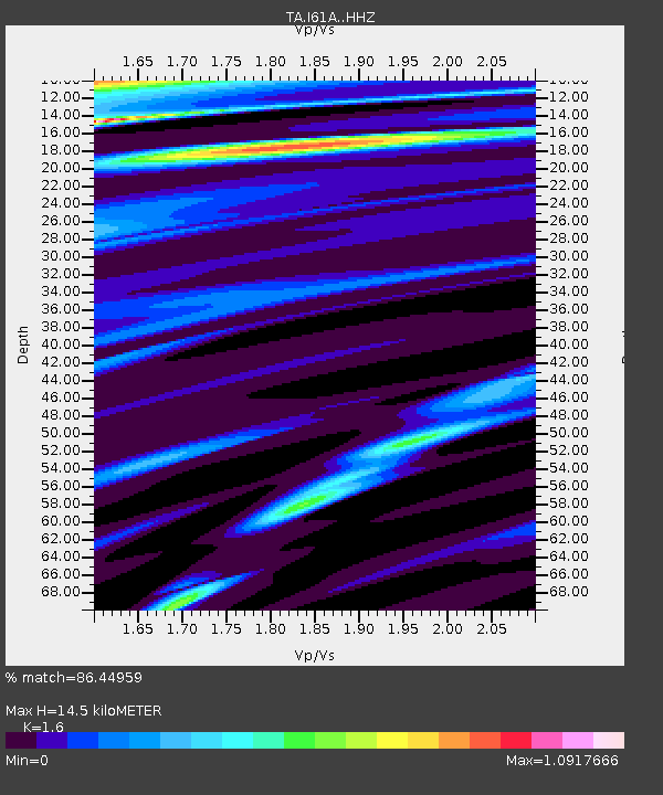
| Estimated Moho Depth: |
14.5 km |
| Estimated Crust Vp/Vs: |
1.60 |
| Assumed Crust Vp: |
6.419 km/s |
| Estimated Crust Vs: |
4.012 km/s |
| Estimated Crust Poisson's Ratio: |
0.18 |
|
| Radial Match: |
86.44959 % |
| Radial Bump: |
400 |
| Transverse Match: |
53.66163 % |
| Transverse Bump: |
400 |
| SOD ConfigId: |
7019011 |
| Insert Time: |
2019-04-16 17:32:22.052 +0000 |
| GWidth: |
2.5 |
| Max Bumps: |
400 |
| Tol: |
0.001 |
|

Signal To Noise
| Channel | StoN | STA | LTA |
| TA:I61A: :HHZ:20150209T20:24:11.249995Z | 2.1724935 | 2.7457356E-6 | 1.2638636E-6 |
| TA:I61A: :HHN:20150209T20:24:11.249995Z | 2.2817776 | 1.6371403E-6 | 7.174846E-7 |
| TA:I61A: :HHE:20150209T20:24:11.249995Z | 1.3493285 | 1.7483682E-6 | 1.2957321E-6 |
| Arrivals |
| Ps | 1.4 SECOND |
| PpPs | 5.7 SECOND |
| PsPs/PpSs | 7.1 SECOND |


