You are here: Home > Network List > US - United States National Seismic Network Stations List
> Station MVCO Mesa Verde, Colorado, USA > Earthquake Result Viewer
MVCO Mesa Verde, Colorado, USA - Earthquake Result Viewer
| Earthquake location: |
Solomon Islands |
| Earthquake latitude/longitude: |
-11.5/162.1 |
| Earthquake time(UTC): |
2014/04/13 (103) 12:36:18 GMT |
| Earthquake Depth: |
35 km |
| Earthquake Magnitude: |
7.4 MWW, 7.7 MI |
| Earthquake Catalog/Contributor: |
NEIC PDE/NEIC COMCAT |
|
| Network: |
US United States National Seismic Network |
| Station: |
MVCO Mesa Verde, Colorado, USA |
| Lat/Lon: |
37.21 N/108.50 W |
| Elevation: |
2170 m |
|
| Distance: |
96.4 deg |
| Az: |
53.446 deg |
| Baz: |
260.541 deg |
| Ray Param: |
0.040517263 |
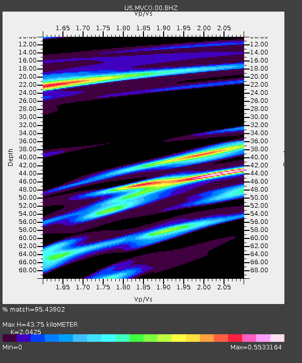
| Estimated Moho Depth: |
43.75 km |
| Estimated Crust Vp/Vs: |
2.04 |
| Assumed Crust Vp: |
6.476 km/s |
| Estimated Crust Vs: |
3.171 km/s |
| Estimated Crust Poisson's Ratio: |
0.34 |
|
| Radial Match: |
95.43902 % |
| Radial Bump: |
312 |
| Transverse Match: |
83.600655 % |
| Transverse Bump: |
400 |
| SOD ConfigId: |
626651 |
| Insert Time: |
2014-04-27 13:04:13.053 +0000 |
| GWidth: |
2.5 |
| Max Bumps: |
400 |
| Tol: |
0.001 |
|

Signal To Noise
| Channel | StoN | STA | LTA |
| US:MVCO:00:BHZ:20140413T12:49:12.525002Z | 12.789948 | 1.1549422E-6 | 9.030077E-8 |
| US:MVCO:00:BH1:20140413T12:49:12.525002Z | 1.6866053 | 2.1517666E-7 | 1.2757974E-7 |
| US:MVCO:00:BH2:20140413T12:49:12.525002Z | 1.9600095 | 1.7796508E-7 | 9.079807E-8 |
| Arrivals |
| Ps | 7.2 SECOND |
| PpPs | 20 SECOND |
| PsPs/PpSs | 27 SECOND |


