You are here: Home > Network List > TA - USArray Transportable Network (new EarthScope stations) Stations List
> Station Z41A Richland Creek Farm, El Dorado, AR, USA > Earthquake Result Viewer
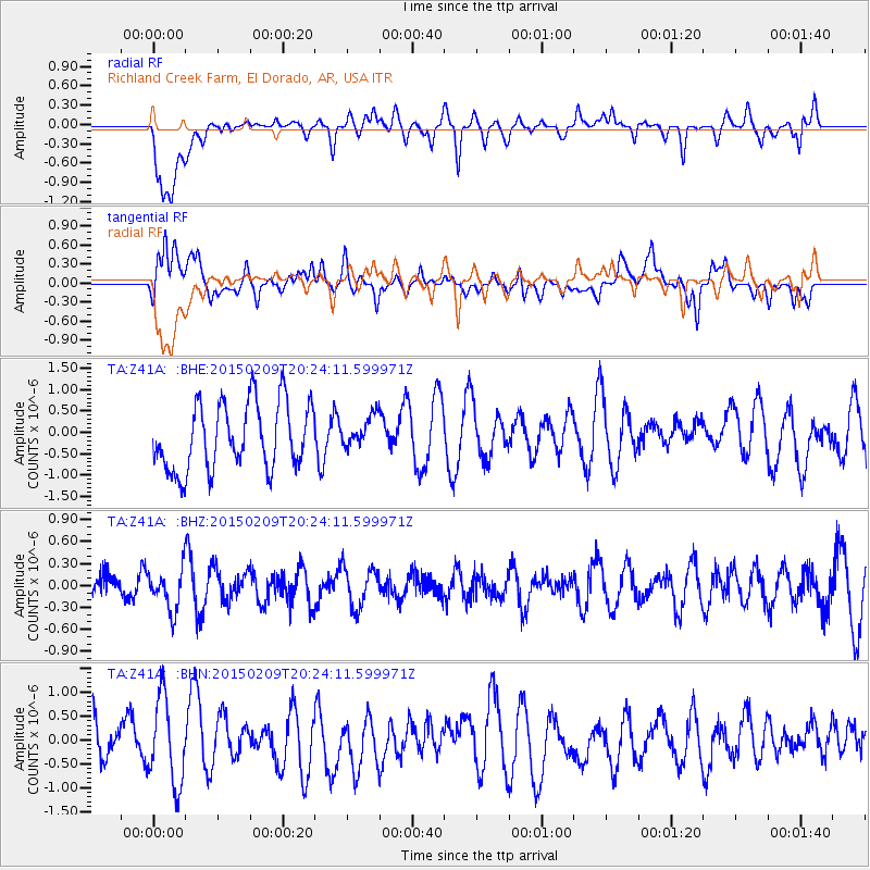
Z41A Richland Creek Farm, El Dorado, AR, USA - Earthquake Result Viewer
*The percent match for this event was below the threshold and hence no stack was calculated.
| Earthquake location: |
Kuril Islands |
| Earthquake latitude/longitude: |
44.0/146.9 |
| Earthquake time(UTC): |
2015/02/09 (040) 20:12:13 GMT |
| Earthquake Depth: |
89 km |
| Earthquake Magnitude: |
4.9 mb |
| Earthquake Catalog/Contributor: |
ISC/ISC |
|
| Network: |
TA USArray Transportable Network (new EarthScope stations) |
| Station: |
Z41A Richland Creek Farm, El Dorado, AR, USA |
| Lat/Lon: |
33.26 N/92.80 W |
| Elevation: |
62 m |
|
| Distance: |
85.8 deg |
| Az: |
46.507 deg |
| Baz: |
321.331 deg |
| Ray Param: |
$rayparam |
*The percent match for this event was below the threshold and hence was not used in the summary stack. |
|
| Radial Match: |
55.067287 % |
| Radial Bump: |
400 |
| Transverse Match: |
40.20011 % |
| Transverse Bump: |
400 |
| SOD ConfigId: |
7019011 |
| Insert Time: |
2019-04-16 17:32:53.446 +0000 |
| GWidth: |
2.5 |
| Max Bumps: |
400 |
| Tol: |
0.001 |
|
Signal To Noise
| Channel | StoN | STA | LTA |
| TA:Z41A: :BHZ:20150209T20:24:11.599971Z | 1.4841168 | 2.8226285E-7 | 1.9018911E-7 |
| TA:Z41A: :BHN:20150209T20:24:11.599971Z | 1.7089305 | 9.0127907E-7 | 5.2739364E-7 |
| TA:Z41A: :BHE:20150209T20:24:11.599971Z | 0.4787473 | 3.7500826E-7 | 7.8331146E-7 |
| Arrivals |
| Ps | |
| PpPs | |
| PsPs/PpSs | |


