You are here: Home > Network List > US - United States National Seismic Network Stations List
> Station TPNV Topopah Spring, Nevada, USA > Earthquake Result Viewer
TPNV Topopah Spring, Nevada, USA - Earthquake Result Viewer
| Earthquake location: |
Solomon Islands |
| Earthquake latitude/longitude: |
-11.5/162.1 |
| Earthquake time(UTC): |
2014/04/13 (103) 12:36:18 GMT |
| Earthquake Depth: |
35 km |
| Earthquake Magnitude: |
7.4 MWW, 7.7 MI |
| Earthquake Catalog/Contributor: |
NEIC PDE/NEIC COMCAT |
|
| Network: |
US United States National Seismic Network |
| Station: |
TPNV Topopah Spring, Nevada, USA |
| Lat/Lon: |
36.95 N/116.25 W |
| Elevation: |
1600 m |
|
| Distance: |
90.3 deg |
| Az: |
52.437 deg |
| Baz: |
255.941 deg |
| Ray Param: |
0.041682154 |
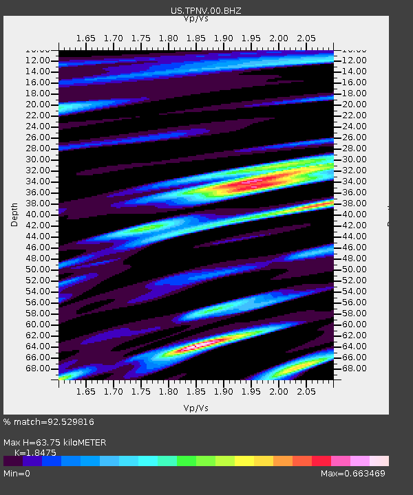
| Estimated Moho Depth: |
63.75 km |
| Estimated Crust Vp/Vs: |
1.85 |
| Assumed Crust Vp: |
6.279 km/s |
| Estimated Crust Vs: |
3.398 km/s |
| Estimated Crust Poisson's Ratio: |
0.29 |
|
| Radial Match: |
92.529816 % |
| Radial Bump: |
400 |
| Transverse Match: |
88.62396 % |
| Transverse Bump: |
400 |
| SOD ConfigId: |
626651 |
| Insert Time: |
2014-04-27 13:04:23.449 +0000 |
| GWidth: |
2.5 |
| Max Bumps: |
400 |
| Tol: |
0.001 |
|
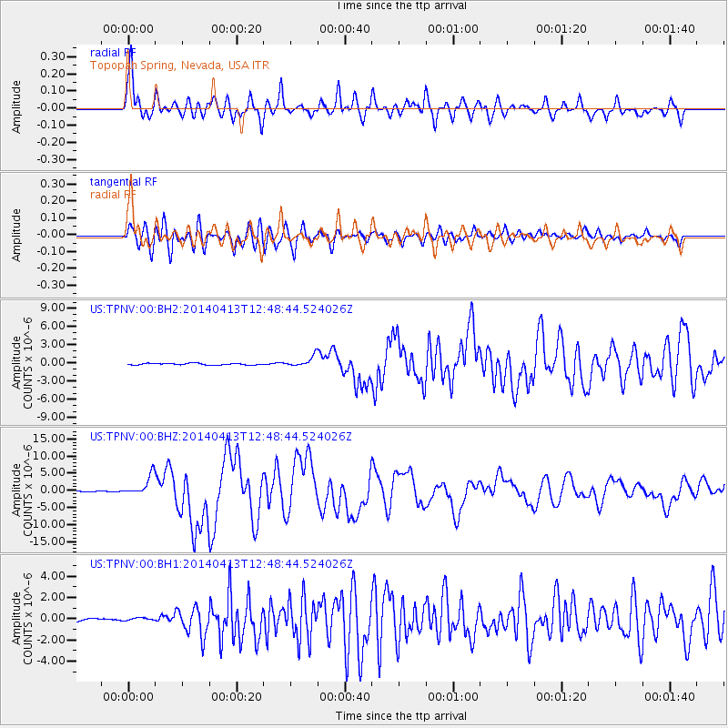
Signal To Noise
| Channel | StoN | STA | LTA |
| US:TPNV:00:BHZ:20140413T12:48:44.524026Z | 24.365248 | 3.0090237E-6 | 1.2349655E-7 |
| US:TPNV:00:BH1:20140413T12:48:44.524026Z | 1.0186042 | 1.4101408E-7 | 1.3843855E-7 |
| US:TPNV:00:BH2:20140413T12:48:44.524026Z | 6.785585 | 8.737052E-7 | 1.28759E-7 |
| Arrivals |
| Ps | 8.8 SECOND |
| PpPs | 28 SECOND |
| PsPs/PpSs | 37 SECOND |


