You are here: Home > Network List > UU - University of Utah Regional Network Stations List
> Station BGU Big Grassy Mountain, UT, USA > Earthquake Result Viewer
BGU Big Grassy Mountain, UT, USA - Earthquake Result Viewer
| Earthquake location: |
Solomon Islands |
| Earthquake latitude/longitude: |
-11.5/162.1 |
| Earthquake time(UTC): |
2014/04/13 (103) 12:36:18 GMT |
| Earthquake Depth: |
35 km |
| Earthquake Magnitude: |
7.4 MWW, 7.7 MI |
| Earthquake Catalog/Contributor: |
NEIC PDE/NEIC COMCAT |
|
| Network: |
UU University of Utah Regional Network |
| Station: |
BGU Big Grassy Mountain, UT, USA |
| Lat/Lon: |
40.92 N/113.03 W |
| Elevation: |
1640 m |
|
| Distance: |
93.6 deg |
| Az: |
49.137 deg |
| Baz: |
258.069 deg |
| Ray Param: |
0.04121805 |
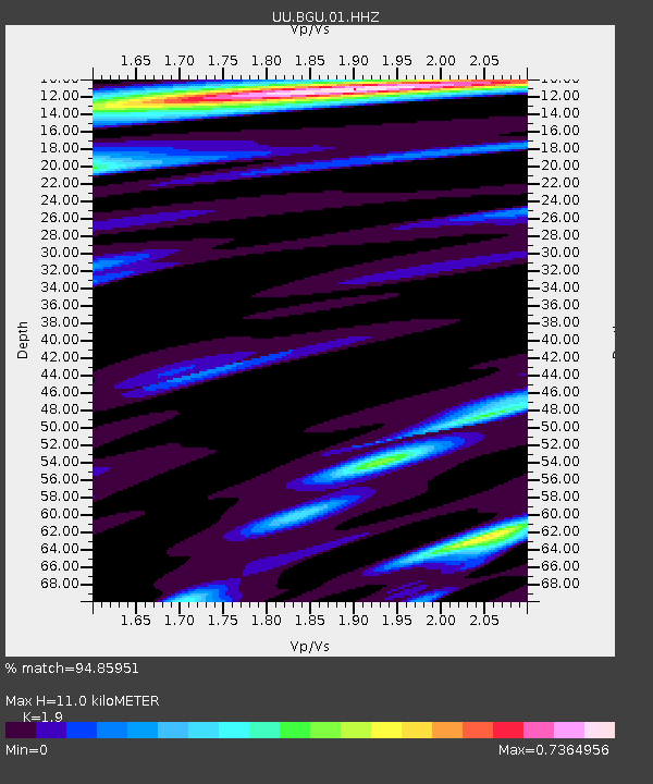
| Estimated Moho Depth: |
11.0 km |
| Estimated Crust Vp/Vs: |
1.90 |
| Assumed Crust Vp: |
6.276 km/s |
| Estimated Crust Vs: |
3.303 km/s |
| Estimated Crust Poisson's Ratio: |
0.31 |
|
| Radial Match: |
94.85951 % |
| Radial Bump: |
305 |
| Transverse Match: |
78.378235 % |
| Transverse Bump: |
400 |
| SOD ConfigId: |
626651 |
| Insert Time: |
2014-04-27 13:04:34.308 +0000 |
| GWidth: |
2.5 |
| Max Bumps: |
400 |
| Tol: |
0.001 |
|

Signal To Noise
| Channel | StoN | STA | LTA |
| UU:BGU:01:HHZ:20140413T12:48:59.887979Z | 23.153263 | 5.556896E-8 | 2.4000488E-9 |
| UU:BGU:01:HHN:20140413T12:48:59.887979Z | 3.1764398 | 6.7005606E-9 | 2.1094564E-9 |
| UU:BGU:01:HHE:20140413T12:48:59.887979Z | 3.1280575 | 1.6389455E-8 | 5.2394995E-9 |
| Arrivals |
| Ps | 1.6 SECOND |
| PpPs | 5.0 SECOND |
| PsPs/PpSs | 6.6 SECOND |


