You are here: Home > Network List > US - United States National Seismic Network Stations List
> Station AMTX Amarillo, Texas, USA > Earthquake Result Viewer
AMTX Amarillo, Texas, USA - Earthquake Result Viewer
*The percent match for this event was below the threshold and hence no stack was calculated.
| Earthquake location: |
Kuril Islands |
| Earthquake latitude/longitude: |
44.0/146.9 |
| Earthquake time(UTC): |
2015/02/09 (040) 20:12:13 GMT |
| Earthquake Depth: |
89 km |
| Earthquake Magnitude: |
4.9 mb |
| Earthquake Catalog/Contributor: |
ISC/ISC |
|
| Network: |
US United States National Seismic Network |
| Station: |
AMTX Amarillo, Texas, USA |
| Lat/Lon: |
34.53 N/101.41 W |
| Elevation: |
1010 m |
|
| Distance: |
80.2 deg |
| Az: |
51.132 deg |
| Baz: |
317.112 deg |
| Ray Param: |
$rayparam |
*The percent match for this event was below the threshold and hence was not used in the summary stack. |
|
| Radial Match: |
46.16728 % |
| Radial Bump: |
400 |
| Transverse Match: |
44.831085 % |
| Transverse Bump: |
400 |
| SOD ConfigId: |
7019011 |
| Insert Time: |
2019-04-16 17:33:15.344 +0000 |
| GWidth: |
2.5 |
| Max Bumps: |
400 |
| Tol: |
0.001 |
|
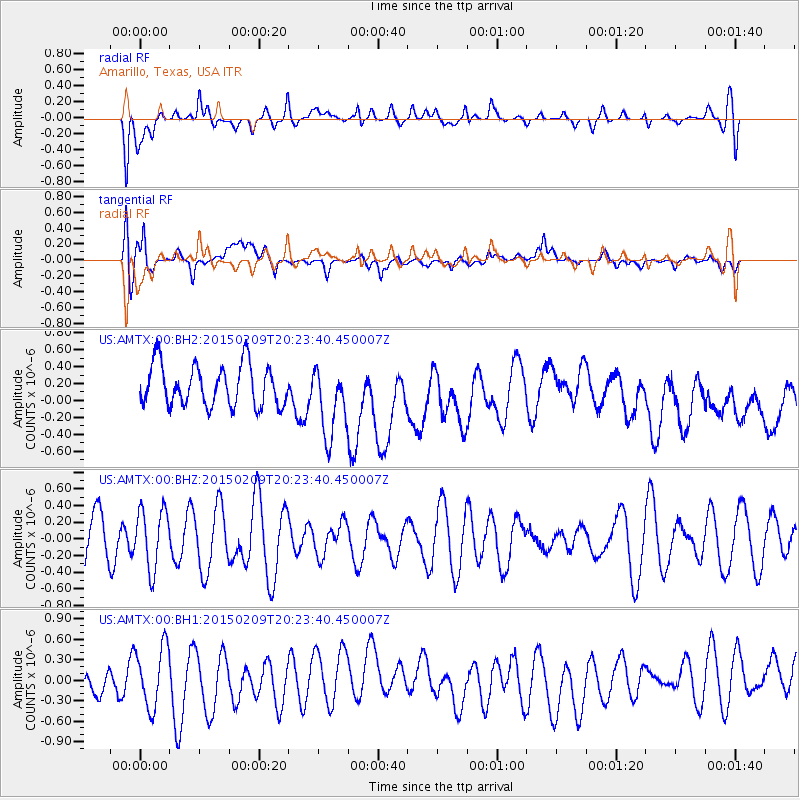
Signal To Noise
| Channel | StoN | STA | LTA |
| US:AMTX:00:BHZ:20150209T20:23:40.450007Z | 1.3495166 | 3.559275E-7 | 2.6374443E-7 |
| US:AMTX:00:BH1:20150209T20:23:40.450007Z | 1.6925905 | 4.48929E-7 | 2.652319E-7 |
| US:AMTX:00:BH2:20150209T20:23:40.450007Z | 2.3082569 | 5.813426E-7 | 2.518535E-7 |
| Arrivals |
| Ps | |
| PpPs | |
| PsPs/PpSs | |


