You are here: Home > Network List > UW - Pacific Northwest Regional Seismic Network Stations List
> Station PASS Maple Falls, WA, USA > Earthquake Result Viewer
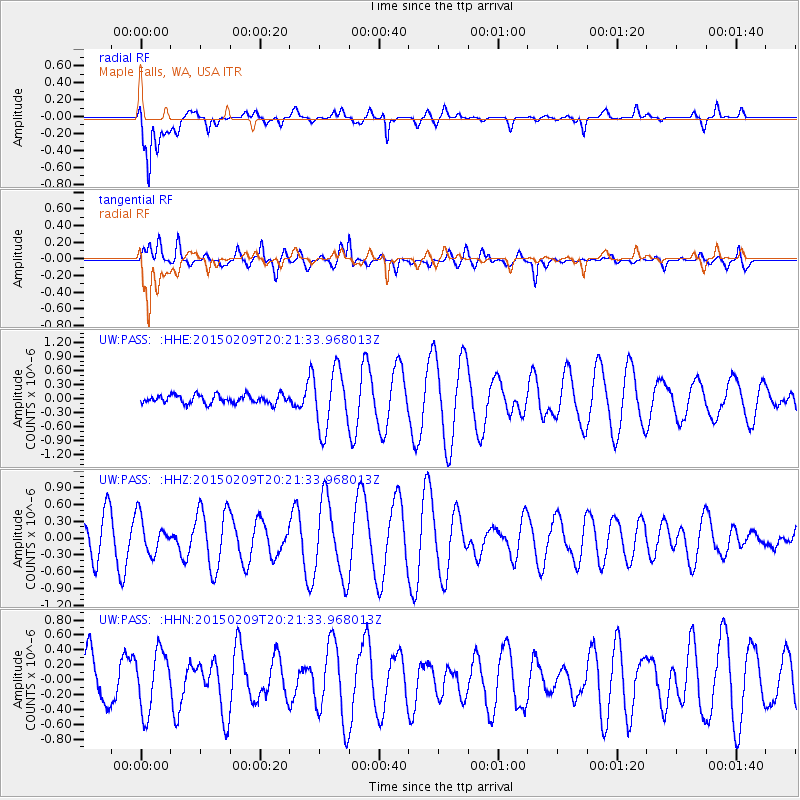
PASS Maple Falls, WA, USA - Earthquake Result Viewer
*The percent match for this event was below the threshold and hence no stack was calculated.
| Earthquake location: |
Kuril Islands |
| Earthquake latitude/longitude: |
44.0/146.9 |
| Earthquake time(UTC): |
2015/02/09 (040) 20:12:13 GMT |
| Earthquake Depth: |
89 km |
| Earthquake Magnitude: |
4.9 mb |
| Earthquake Catalog/Contributor: |
ISC/ISC |
|
| Network: |
UW Pacific Northwest Regional Seismic Network |
| Station: |
PASS Maple Falls, WA, USA |
| Lat/Lon: |
49.00 N/122.09 W |
| Elevation: |
174 m |
|
| Distance: |
59.2 deg |
| Az: |
50.076 deg |
| Baz: |
302.823 deg |
| Ray Param: |
$rayparam |
*The percent match for this event was below the threshold and hence was not used in the summary stack. |
|
| Radial Match: |
75.94825 % |
| Radial Bump: |
400 |
| Transverse Match: |
64.92309 % |
| Transverse Bump: |
400 |
| SOD ConfigId: |
7019011 |
| Insert Time: |
2019-04-16 17:33:39.064 +0000 |
| GWidth: |
2.5 |
| Max Bumps: |
400 |
| Tol: |
0.001 |
|
Signal To Noise
| Channel | StoN | STA | LTA |
| UW:PASS: :HHZ:20150209T20:21:33.968013Z | 0.82046586 | 3.224677E-7 | 3.9303E-7 |
| UW:PASS: :HHN:20150209T20:21:33.968013Z | 0.8646701 | 4.0109725E-7 | 4.6387316E-7 |
| UW:PASS: :HHE:20150209T20:21:33.968013Z | 6.8648086 | 6.366893E-7 | 9.2746845E-8 |
| Arrivals |
| Ps | |
| PpPs | |
| PsPs/PpSs | |


