You are here: Home > Network List > UW - Pacific Northwest Regional Seismic Network Stations List
> Station LON Longmire (broad-band and DWWSSN) > Earthquake Result Viewer
LON Longmire (broad-band and DWWSSN) - Earthquake Result Viewer
| Earthquake location: |
Solomon Islands |
| Earthquake latitude/longitude: |
-11.5/162.1 |
| Earthquake time(UTC): |
2014/04/13 (103) 12:36:18 GMT |
| Earthquake Depth: |
35 km |
| Earthquake Magnitude: |
7.4 MWW, 7.7 MI |
| Earthquake Catalog/Contributor: |
NEIC PDE/NEIC COMCAT |
|
| Network: |
UW Pacific Northwest Regional Seismic Network |
| Station: |
LON Longmire (broad-band and DWWSSN) |
| Lat/Lon: |
46.75 N/121.81 W |
| Elevation: |
850 m |
|
| Distance: |
88.9 deg |
| Az: |
41.887 deg |
| Baz: |
252.156 deg |
| Ray Param: |
0.04216759 |
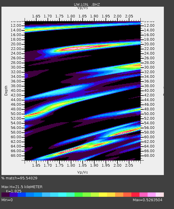
| Estimated Moho Depth: |
21.5 km |
| Estimated Crust Vp/Vs: |
1.83 |
| Assumed Crust Vp: |
6.597 km/s |
| Estimated Crust Vs: |
3.615 km/s |
| Estimated Crust Poisson's Ratio: |
0.29 |
|
| Radial Match: |
95.54829 % |
| Radial Bump: |
400 |
| Transverse Match: |
84.891174 % |
| Transverse Bump: |
400 |
| SOD ConfigId: |
626651 |
| Insert Time: |
2014-04-27 13:06:19.034 +0000 |
| GWidth: |
2.5 |
| Max Bumps: |
400 |
| Tol: |
0.001 |
|

Signal To Noise
| Channel | StoN | STA | LTA |
| UW:LON: :BHZ:20140413T12:48:38.410012Z | 30.508936 | 3.0970834E-6 | 1.01513976E-7 |
| UW:LON: :BHN:20140413T12:48:38.410012Z | 5.4708676 | 4.4127864E-7 | 8.065972E-8 |
| UW:LON: :BHE:20140413T12:48:38.410012Z | 11.453039 | 9.697507E-7 | 8.467191E-8 |
| Arrivals |
| Ps | 2.7 SECOND |
| PpPs | 9.0 SECOND |
| PsPs/PpSs | 12 SECOND |


