You are here: Home > Network List > II - Global Seismograph Network (GSN - IRIS/IDA) Stations List
> Station KDAK Kodiak Island, Alaska, USA > Earthquake Result Viewer
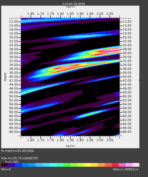
KDAK Kodiak Island, Alaska, USA - Earthquake Result Viewer
| Earthquake location: |
Northern Molucca Sea |
| Earthquake latitude/longitude: |
2.8/126.5 |
| Earthquake time(UTC): |
2005/07/09 (190) 10:07:01 GMT |
| Earthquake Depth: |
22 km |
| Earthquake Magnitude: |
5.8 MB, 5.2 MS, 5.9 MW, 5.8 MW |
| Earthquake Catalog/Contributor: |
WHDF/NEIC |
|
| Network: |
II Global Seismograph Network (GSN - IRIS/IDA) |
| Station: |
KDAK Kodiak Island, Alaska, USA |
| Lat/Lon: |
57.78 N/152.58 W |
| Elevation: |
152 m |
|
| Distance: |
82.8 deg |
| Az: |
32.216 deg |
| Baz: |
263.748 deg |
| Ray Param: |
0.046599634 |
| Estimated Moho Depth: |
25.75 km |
| Estimated Crust Vp/Vs: |
2.09 |
| Assumed Crust Vp: |
6.134 km/s |
| Estimated Crust Vs: |
2.942 km/s |
| Estimated Crust Poisson's Ratio: |
0.35 |
|
| Radial Match: |
85.652466 % |
| Radial Bump: |
400 |
| Transverse Match: |
73.84301 % |
| Transverse Bump: |
400 |
| SOD ConfigId: |
2422 |
| Insert Time: |
2010-03-01 20:59:00.952 +0000 |
| GWidth: |
2.5 |
| Max Bumps: |
400 |
| Tol: |
0.001 |
|

Signal To Noise
| Channel | StoN | STA | LTA |
| II:KDAK:00:BHN:20050709T10:18:52.400017Z | 2.1013684 | 1.5147945E-7 | 7.2086095E-8 |
| II:KDAK:00:BHE:20050709T10:18:52.400017Z | 2.2663383 | 1.7608868E-7 | 7.7697436E-8 |
| II:KDAK:00:BHZ:20050709T10:18:52.400017Z | 8.847897 | 6.442679E-7 | 7.281594E-8 |
| Arrivals |
| Ps | 4.6 SECOND |
| PpPs | 13 SECOND |
| PsPs/PpSs | 17 SECOND |


