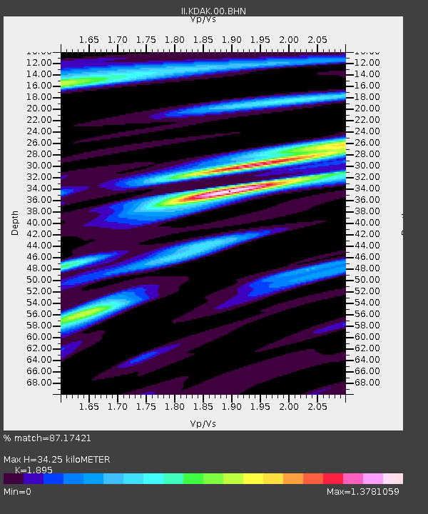
KDAK Kodiak Island, Alaska, USA - Earthquake Result Viewer
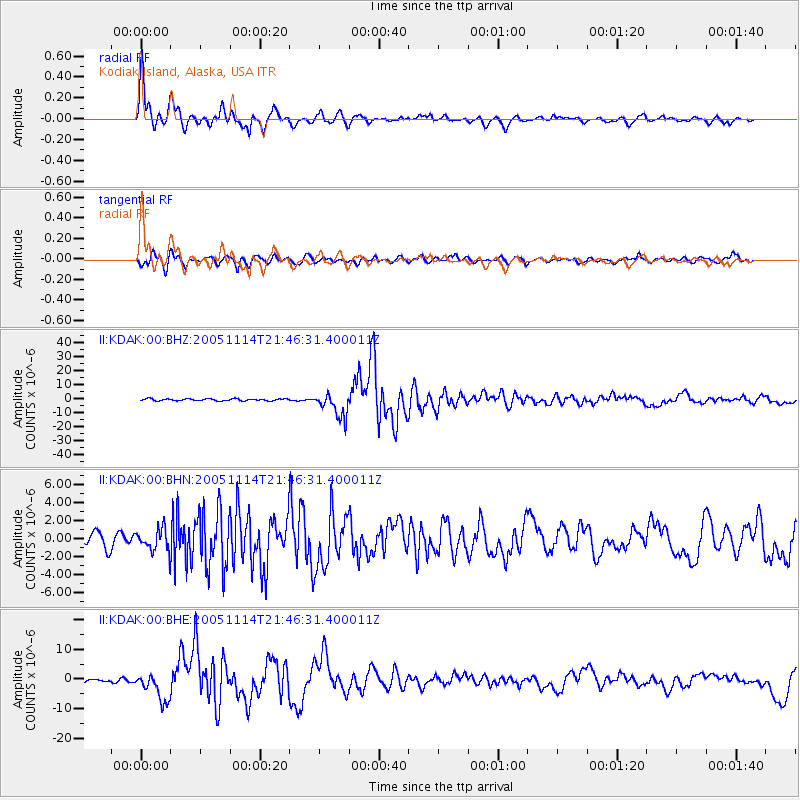
Earthquake location: Off East Coast Of Honshu, Japan
Earthquake latitude/longitude: 38.1/144.9
Earthquake time(UTC): 2005/11/14 (318) 21:38:51 GMT
Earthquake Depth: 11 km
Earthquake Magnitude: 6.7 MB, 6.8 MS, 7.0 MW, 6.9 MW
Earthquake Catalog/Contributor: WHDF/NEIC
Network: II Global Seismograph Network (GSN - IRIS/IDA)
Station: KDAK Kodiak Island, Alaska, USA
Lat/Lon: 57.78 N/152.58 W
Elevation: 152 m
Distance: 44.4 deg
Az: 42.745 deg
Baz: 271.788 deg
Ray Param: 0.071910664
Estimated Moho Depth: 34.25 km
Estimated Crust Vp/Vs: 1.89
Assumed Crust Vp: 6.134 km/s
Estimated Crust Vs: 3.237 km/s
Estimated Crust Poisson's Ratio: 0.31
Radial Match: 87.17421 %
Radial Bump: 380
Transverse Match: 75.60326 %
Transverse Bump: 400
SOD ConfigId: 2448
Insert Time: 2010-03-01 20:59:04.817 +0000
GWidth: 2.5
Max Bumps: 400
Tol: 0.001

Signal To Noise

ChannelStoNSTALTA
II:KDAK:00:BHN:20051114T21:46:31.400011Z1.6806821.1979389E-67.127695E-7
II:KDAK:00:BHE:20051114T21:46:31.400011Z7.36253934.7116223E-66.3994526E-7
II:KDAK:00:BHZ:20051114T21:46:31.400011Z12.5516498.737512E-66.9612463E-7
Arrivals
Ps5.3 SECOND
PpPs15 SECOND
PsPs/PpSs21 SECOND