You are here: Home > Network List > AV - Alaska Volcano Observatory Stations List
> Station SPCR Ckakachatna River, Mount Spurr, Alaska > Earthquake Result Viewer
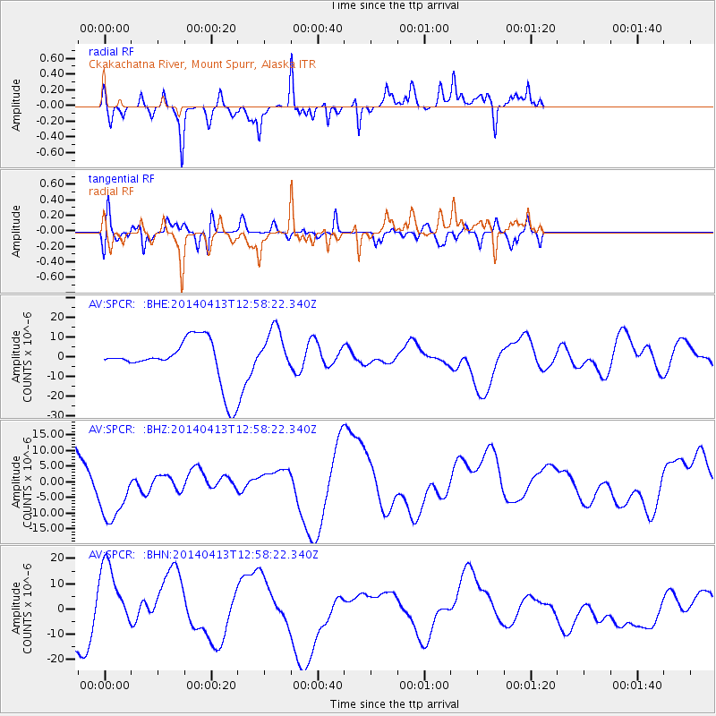
SPCR Ckakachatna River, Mount Spurr, Alaska - Earthquake Result Viewer
*The percent match for this event was below the threshold and hence no stack was calculated.
| Earthquake location: |
Solomon Islands |
| Earthquake latitude/longitude: |
-11.5/162.3 |
| Earthquake time(UTC): |
2014/04/13 (103) 12:46:43 GMT |
| Earthquake Depth: |
31 km |
| Earthquake Magnitude: |
5.7 MB |
| Earthquake Catalog/Contributor: |
NEIC PDE/NEIC COMCAT |
|
| Network: |
AV Alaska Volcano Observatory |
| Station: |
SPCR Ckakachatna River, Mount Spurr, Alaska |
| Lat/Lon: |
61.20 N/152.21 W |
| Elevation: |
984 m |
|
| Distance: |
80.8 deg |
| Az: |
20.467 deg |
| Baz: |
225.066 deg |
| Ray Param: |
$rayparam |
*The percent match for this event was below the threshold and hence was not used in the summary stack. |
|
| Radial Match: |
48.835262 % |
| Radial Bump: |
322 |
| Transverse Match: |
53.43689 % |
| Transverse Bump: |
400 |
| SOD ConfigId: |
626651 |
| Insert Time: |
2014-04-27 13:12:21.631 +0000 |
| GWidth: |
2.5 |
| Max Bumps: |
400 |
| Tol: |
0.001 |
|
Signal To Noise
| Channel | StoN | STA | LTA |
| AV:SPCR: :BHZ:20140413T12:58:22.340Z | 1.3423237 | 1.0547636E-5 | 7.857744E-6 |
| AV:SPCR: :BHN:20140413T12:58:22.340Z | 1.1115832 | 1.3929307E-5 | 1.2531052E-5 |
| AV:SPCR: :BHE:20140413T12:58:22.340Z | 1.0496649 | 1.1642159E-5 | 1.109131E-5 |
| Arrivals |
| Ps | |
| PpPs | |
| PsPs/PpSs | |


