You are here: Home > Network List > TA - USArray Transportable Network (new EarthScope stations) Stations List
> Station G05D Wamic, OR, USA > Earthquake Result Viewer
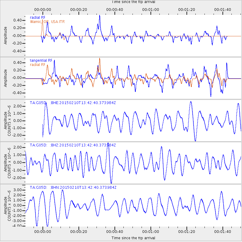
G05D Wamic, OR, USA - Earthquake Result Viewer
*The percent match for this event was below the threshold and hence no stack was calculated.
| Earthquake location: |
Philippine Islands Region |
| Earthquake latitude/longitude: |
11.3/126.2 |
| Earthquake time(UTC): |
2015/02/10 (041) 13:29:44 GMT |
| Earthquake Depth: |
49 km |
| Earthquake Magnitude: |
5.4 MW |
| Earthquake Catalog/Contributor: |
ISC/ISC |
|
| Network: |
TA USArray Transportable Network (new EarthScope stations) |
| Station: |
G05D Wamic, OR, USA |
| Lat/Lon: |
45.24 N/121.32 W |
| Elevation: |
592 m |
|
| Distance: |
97.3 deg |
| Az: |
41.174 deg |
| Baz: |
293.916 deg |
| Ray Param: |
$rayparam |
*The percent match for this event was below the threshold and hence was not used in the summary stack. |
|
| Radial Match: |
43.941975 % |
| Radial Bump: |
400 |
| Transverse Match: |
52.708267 % |
| Transverse Bump: |
400 |
| SOD ConfigId: |
7019011 |
| Insert Time: |
2019-04-16 17:39:34.611 +0000 |
| GWidth: |
2.5 |
| Max Bumps: |
400 |
| Tol: |
0.001 |
|
Signal To Noise
| Channel | StoN | STA | LTA |
| TA:G05D: :BHZ:20150210T13:42:40.373984Z | 1.0585763 | 9.115088E-7 | 8.610704E-7 |
| TA:G05D: :BHN:20150210T13:42:40.373984Z | 2.9205685 | 2.4849894E-6 | 8.5085816E-7 |
| TA:G05D: :BHE:20150210T13:42:40.373984Z | 1.0892897 | 9.855529E-7 | 9.047666E-7 |
| Arrivals |
| Ps | |
| PpPs | |
| PsPs/PpSs | |


