You are here: Home > Network List > IU - Global Seismograph Network (GSN - IRIS/USGS) Stations List
> Station SNZO South Karori, New Zealand > Earthquake Result Viewer
SNZO South Karori, New Zealand - Earthquake Result Viewer
| Earthquake location: |
Solomon Islands |
| Earthquake latitude/longitude: |
-11.5/162.3 |
| Earthquake time(UTC): |
2014/04/13 (103) 12:46:43 GMT |
| Earthquake Depth: |
31 km |
| Earthquake Magnitude: |
5.7 MB |
| Earthquake Catalog/Contributor: |
NEIC PDE/NEIC COMCAT |
|
| Network: |
IU Global Seismograph Network (GSN - IRIS/USGS) |
| Station: |
SNZO South Karori, New Zealand |
| Lat/Lon: |
41.31 S/174.70 E |
| Elevation: |
120 m |
|
| Distance: |
31.7 deg |
| Az: |
162.087 deg |
| Baz: |
336.406 deg |
| Ray Param: |
0.07893568 |
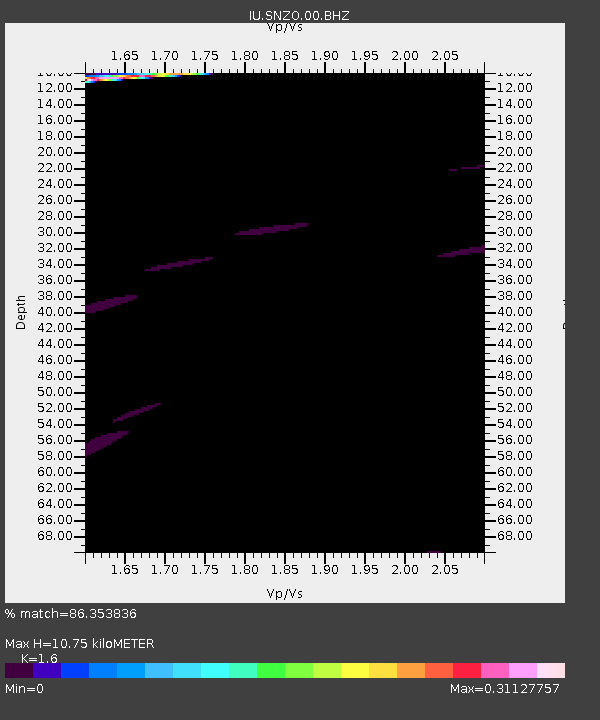
| Estimated Moho Depth: |
10.75 km |
| Estimated Crust Vp/Vs: |
1.60 |
| Assumed Crust Vp: |
6.461 km/s |
| Estimated Crust Vs: |
4.038 km/s |
| Estimated Crust Poisson's Ratio: |
0.18 |
|
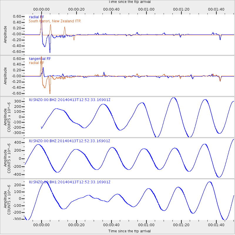
| Radial Match: |
86.353836 % |
| Radial Bump: |
295 |
| Transverse Match: |
83.541954 % |
| Transverse Bump: |
318 |
| SOD ConfigId: |
626651 |
| Insert Time: |
2014-04-27 13:16:26.688 +0000 |
| GWidth: |
2.5 |
| Max Bumps: |
400 |
| Tol: |
0.001 |
|
Signal To Noise
| Channel | StoN | STA | LTA |
| IU:SNZO:00:BHZ:20140413T12:52:33.16901Z | 1.0753813 | 2.3225816E-4 | 2.159775E-4 |
| IU:SNZO:00:BH1:20140413T12:52:33.16901Z | 1.4754953 | 2.541453E-4 | 1.7224405E-4 |
| IU:SNZO:00:BH2:20140413T12:52:33.16901Z | 1.2621317 | 1.5986025E-4 | 1.2665892E-4 |
| Arrivals |
| Ps | 1.1 SECOND |
| PpPs | 4.0 SECOND |
| PsPs/PpSs | 5.0 SECOND |


