You are here: Home > Network List > II - Global Seismograph Network (GSN - IRIS/IDA) Stations List
> Station KDAK Kodiak Island, Alaska, USA > Earthquake Result Viewer
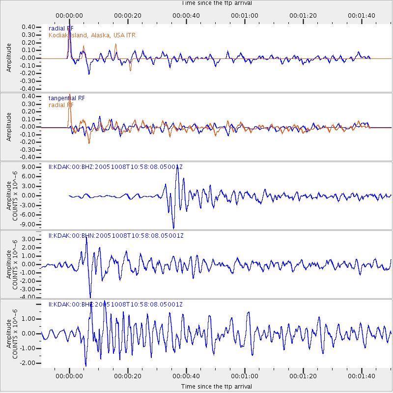
KDAK Kodiak Island, Alaska, USA - Earthquake Result Viewer

| Earthquake location: |
Pakistan |
| Earthquake latitude/longitude: |
34.7/73.1 |
| Earthquake time(UTC): |
2005/10/08 (281) 10:46:28 GMT |
| Earthquake Depth: |
8.0 km |
| Earthquake Magnitude: |
6.0 MB, 6.3 MS, 6.4 MW, 6.2 MW |
| Earthquake Catalog/Contributor: |
WHDF/NEIC |
|
| Network: |
II Global Seismograph Network (GSN - IRIS/IDA) |
| Station: |
KDAK Kodiak Island, Alaska, USA |
| Lat/Lon: |
57.78 N/152.58 W |
| Elevation: |
152 m |
|
| Distance: |
80.2 deg |
| Az: |
22.892 deg |
| Baz: |
323.269 deg |
| Ray Param: |
0.04846197 |
| Estimated Moho Depth: |
29.5 km |
| Estimated Crust Vp/Vs: |
1.93 |
| Assumed Crust Vp: |
6.134 km/s |
| Estimated Crust Vs: |
3.182 km/s |
| Estimated Crust Poisson's Ratio: |
0.32 |
|
| Radial Match: |
88.80143 % |
| Radial Bump: |
376 |
| Transverse Match: |
80.01908 % |
| Transverse Bump: |
400 |
| SOD ConfigId: |
2475 |
| Insert Time: |
2010-03-01 20:59:41.810 +0000 |
| GWidth: |
2.5 |
| Max Bumps: |
400 |
| Tol: |
0.001 |
|
Signal To Noise
| Channel | StoN | STA | LTA |
| II:KDAK:00:BHN:20051008T10:58:08.05001Z | 2.3005853 | 5.7600334E-7 | 2.5037255E-7 |
| II:KDAK:00:BHE:20051008T10:58:08.05001Z | 0.94218785 | 2.9208775E-7 | 3.100101E-7 |
| II:KDAK:00:BHZ:20051008T10:58:08.05001Z | 5.1456127 | 1.8583838E-6 | 3.611589E-7 |
| Arrivals |
| Ps | 4.6 SECOND |
| PpPs | 14 SECOND |
| PsPs/PpSs | 18 SECOND |


