You are here: Home > Network List > TA - USArray Transportable Network (new EarthScope stations) Stations List
> Station O03E Paynes Creek, CA, USA > Earthquake Result Viewer
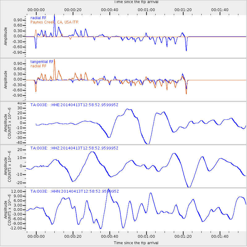
O03E Paynes Creek, CA, USA - Earthquake Result Viewer
*The percent match for this event was below the threshold and hence no stack was calculated.
| Earthquake location: |
Solomon Islands |
| Earthquake latitude/longitude: |
-11.5/162.3 |
| Earthquake time(UTC): |
2014/04/13 (103) 12:46:43 GMT |
| Earthquake Depth: |
31 km |
| Earthquake Magnitude: |
5.7 MB |
| Earthquake Catalog/Contributor: |
NEIC PDE/NEIC COMCAT |
|
| Network: |
TA USArray Transportable Network (new EarthScope stations) |
| Station: |
O03E Paynes Creek, CA, USA |
| Lat/Lon: |
40.29 N/121.80 W |
| Elevation: |
967 m |
|
| Distance: |
86.8 deg |
| Az: |
47.978 deg |
| Baz: |
252.205 deg |
| Ray Param: |
$rayparam |
*The percent match for this event was below the threshold and hence was not used in the summary stack. |
|
| Radial Match: |
62.19106 % |
| Radial Bump: |
400 |
| Transverse Match: |
26.109642 % |
| Transverse Bump: |
400 |
| SOD ConfigId: |
626651 |
| Insert Time: |
2014-04-27 13:19:39.561 +0000 |
| GWidth: |
2.5 |
| Max Bumps: |
400 |
| Tol: |
0.001 |
|
Signal To Noise
| Channel | StoN | STA | LTA |
| TA:O03E: :HHZ:20140413T12:58:52.959995Z | 0.6750957 | 7.171367E-7 | 1.0622742E-6 |
| TA:O03E: :HHN:20140413T12:58:52.959995Z | 3.1415455 | 1.8749389E-6 | 5.9682054E-7 |
| TA:O03E: :HHE:20140413T12:58:52.959995Z | 2.1353974 | 3.0092783E-6 | 1.4092358E-6 |
| Arrivals |
| Ps | |
| PpPs | |
| PsPs/PpSs | |


