You are here: Home > Network List > II - Global Seismograph Network (GSN - IRIS/IDA) Stations List
> Station KDAK Kodiak Island, Alaska, USA > Earthquake Result Viewer
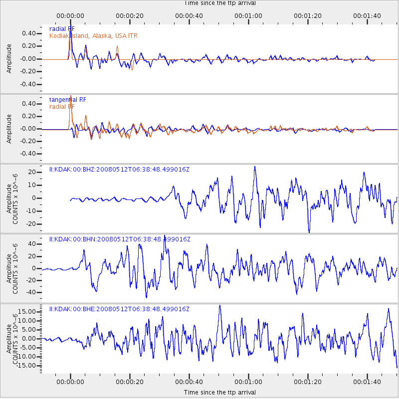
KDAK Kodiak Island, Alaska, USA - Earthquake Result Viewer

| Earthquake location: |
Sichuan, China |
| Earthquake latitude/longitude: |
31.0/103.3 |
| Earthquake time(UTC): |
2008/05/12 (133) 06:28:01 GMT |
| Earthquake Depth: |
19 km |
| Earthquake Magnitude: |
6.9 MB, 8.1 MS, 7.9 MW, 7.9 MW |
| Earthquake Catalog/Contributor: |
WHDF/NEIC |
|
| Network: |
II Global Seismograph Network (GSN - IRIS/IDA) |
| Station: |
KDAK Kodiak Island, Alaska, USA |
| Lat/Lon: |
57.78 N/152.58 W |
| Elevation: |
152 m |
|
| Distance: |
71.3 deg |
| Az: |
33.268 deg |
| Baz: |
298.444 deg |
| Ray Param: |
0.054408744 |
| Estimated Moho Depth: |
52.75 km |
| Estimated Crust Vp/Vs: |
1.60 |
| Assumed Crust Vp: |
6.134 km/s |
| Estimated Crust Vs: |
3.834 km/s |
| Estimated Crust Poisson's Ratio: |
0.18 |
|
| Radial Match: |
95.90599 % |
| Radial Bump: |
391 |
| Transverse Match: |
91.043465 % |
| Transverse Bump: |
400 |
| SOD ConfigId: |
2504 |
| Insert Time: |
2010-03-01 21:00:01.643 +0000 |
| GWidth: |
2.5 |
| Max Bumps: |
400 |
| Tol: |
0.001 |
|
Signal To Noise
| Channel | StoN | STA | LTA |
| II:KDAK:00:BHN:20080512T06:38:48.499016Z | 12.3948765 | 1.1213251E-5 | 9.0466824E-7 |
| II:KDAK:00:BHE:20080512T06:38:48.499016Z | 3.6076825 | 1.9097733E-6 | 5.293629E-7 |
| II:KDAK:00:BHZ:20080512T06:38:48.499016Z | 5.088058 | 3.859448E-6 | 7.585307E-7 |
| Arrivals |
| Ps | 5.4 SECOND |
| PpPs | 22 SECOND |
| PsPs/PpSs | 27 SECOND |


