You are here: Home > Network List > IW - Intermountain West Stations List
> Station RWWY Rawlins, Wyoming, USA > Earthquake Result Viewer
RWWY Rawlins, Wyoming, USA - Earthquake Result Viewer
| Earthquake location: |
Solomon Islands |
| Earthquake latitude/longitude: |
-11.1/162.0 |
| Earthquake time(UTC): |
2014/04/13 (103) 13:25:03 GMT |
| Earthquake Depth: |
35 km |
| Earthquake Magnitude: |
6.6 MWW, 6.7 MWC |
| Earthquake Catalog/Contributor: |
NEIC PDE/NEIC COMCAT |
|
| Network: |
IW Intermountain West |
| Station: |
RWWY Rawlins, Wyoming, USA |
| Lat/Lon: |
41.69 N/107.21 W |
| Elevation: |
2402 m |
|
| Distance: |
97.9 deg |
| Az: |
49.114 deg |
| Baz: |
262.161 deg |
| Ray Param: |
0.04006718 |
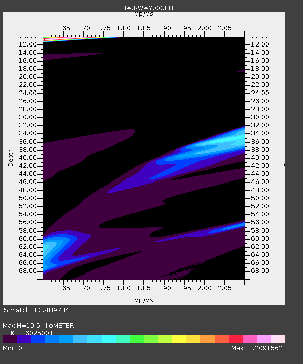
| Estimated Moho Depth: |
10.5 km |
| Estimated Crust Vp/Vs: |
1.60 |
| Assumed Crust Vp: |
6.159 km/s |
| Estimated Crust Vs: |
3.843 km/s |
| Estimated Crust Poisson's Ratio: |
0.18 |
|
| Radial Match: |
83.489784 % |
| Radial Bump: |
309 |
| Transverse Match: |
83.81743 % |
| Transverse Bump: |
281 |
| SOD ConfigId: |
626651 |
| Insert Time: |
2014-04-27 13:38:52.557 +0000 |
| GWidth: |
2.5 |
| Max Bumps: |
400 |
| Tol: |
0.001 |
|

Signal To Noise
| Channel | StoN | STA | LTA |
| IW:RWWY:00:BHZ:20140413T13:38:03.91397Z | 1.8722422 | 9.191527E-6 | 4.9093687E-6 |
| IW:RWWY:00:BH1:20140413T13:38:03.91397Z | 1.3971351 | 1.5550804E-5 | 1.1130494E-5 |
| IW:RWWY:00:BH2:20140413T13:38:03.91397Z | 0.46472684 | 1.3890754E-6 | 2.9890148E-6 |
| Arrivals |
| Ps | 1.0 SECOND |
| PpPs | 4.4 SECOND |
| PsPs/PpSs | 5.4 SECOND |


